
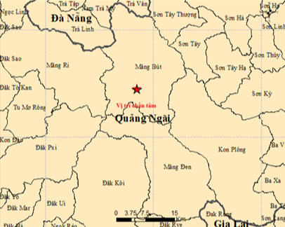
A map shows the epicenter of a magnitude-4.0 earthquake that struck Mang But Commune in Quang Ngai Province, south-central Vietnam at 0:52 local time on February 21, 2026. Photo: Institute of Earth Sciences
The strongest quake, measuring 4.0 on the Richter scale, occurred at 0:52 am, followed within minutes by tremors of magnitude 3.2 and 2.8.
Another magnitude-3.8 earthquake was recorded at 1:29 am.
Two additional quakes, measuring 2.8 and 2.6, were recorded at 2:38 am and 5:30 am, respectively.
The tremors had focal depths of about 8.1 km and were classified at disaster risk level 0, meaning they posed no natural disaster risk, said Nguyen Xuan Anh, director of the iíntitute.
The Vietnam Earthquake Information and Tsunami Warning Center is continuing to monitor the activity.
A magnitude-3.7 earthquake was recorded in Kon Plong Commune on February 15, also classified at risk level 0.
According to the institute, more than 30 earthquakes were recorded in the former Kon Tum Province, which has been merged into Quang Ngai since July 2025, between 1903 and 2020, with the largest measuring 3.9 in magnitude.
Since April 2021, however, hundreds of induced earthquakes have been recorded in the area, particularly around Kon Plong.
The largest in recent years was a magnitude-5.0 quake on July 28, 2024, followed by a magnitude-4.9 tremor on October 6, 2025.
Anh said the recent quakes were induced by reservoir impoundment at hydropower plants and are expected to continue, though they are unlikely to exceed magnitude-5.5.

Max: 1500 characters
There are no comments yet. Be the first to comment.