
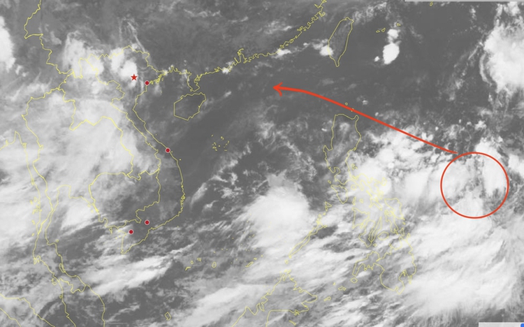
Satellite cloud image of the tropical depression (circled in red) east of the Philippines on the morning of July 16, 2025. Photo: National Center for HydroMeteorological Forecasting
As of 7:00 am on Wednesday, the depression was centered approximately 1,000 km east-southeast of Luzon Island, with sustained winds of up to 49 kph and gusts reaching 74 kph.
Over the next 48 hours, the system is expected to track northwest, strengthen into a tropical storm, sweep across the waters north of the island, and enter the East Vietnam Sea between July 19 and 20, marking it as the third storm of the season in the sea region.
Meteorologists emphasize that unstable atmospheric conditions, such as the southwest monsoon and a subtropical high-pressure zone, could alter both the depression’s trajectory and intensity.
There is currently a 50-60 percent probability that once in the East Vietnam Sea, the system will continue westnorthwest into the northern Gulf of Tonkin by early next week.
Beginning this weekend, maritime regions in the East Vietnam Sea—including the waters of Vietnam’s Hoang Sa (Paracel) and Truong Sa (Spratly) archipelagos—are expected to experience strong winds, high waves, and rough seas.
If the system maintains its projected path toward mainland Vietnam, heavy rainfall may affect areas from Thanh Hoa to Nghe An between July 20 and 25.
Authorities, coastal communities, and maritime operators are urged to monitor official updates closely and implement preventive measures to mitigate any potential impacts.

Max: 1500 characters
There are no comments yet. Be the first to comment.