


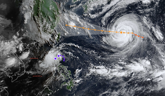
A satellite image shows the projected position and path of typhoon Dolphin early on August 4, 2026. Photo: Vietnam’s National Center for Hydro-Meteorological Forecasting
According to the Japan Meteorological Agency, as of 6:00 am on Tuesday, Dolphin’s center was located more than 1,500 kilometers east of Okinawa.
The storm has weakened slightly compared to Monday, dropping one intensity level, but remains very strong with a well-defined eye and dense convective clouds.
The Japan Meteorological Agency predicts Dolphin will continue moving west toward Okinawa before shifting west-northwest toward China’s mainland.
By Sunday, the storm is expected to weaken further, with sustained winds between 134 and 149 kph.
Vietnam’s National Center for Hydro-Meteorological Forecasting said the Gulf of Tonkin and the northern and central East Vietnam Sea may see scattered showers and thunderstorms on Tuesday, along with whirlwinds, gusts of 50-75 kph, and waves over two meters.
From Thursday to Friday, southwest winds across the northern, central, and southern East Vietnam Sea, including Vietnam’s Hoang Sa (Paracel) and Truong Sa (Spratly) Special Zones, could strengthen to 40-60 kph, with waves rising to four meters and very rough seas.
The national weather agency warned all vessels operating in these waters of the high risk posed by strong winds, whirlwinds, and dangerous waves.








Max: 1500 characters
There are no comments yet. Be the first to comment.