


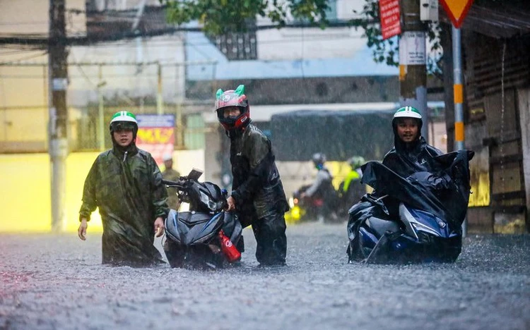
Severe flooding caused by heavy rain submerges motorbike wheels near Thu Duc Market in Ho Chi Minh City, southern Vietnam. Photo: Chau Tuan / Tuoi Tre
The management challenge has expanded significantly following a national administrative restructuring on July 1, 2025, which merged the former Binh Duong and Ba Ria-Vung Tau provinces into the southern Vietnamese hub, creating a vast metropolitan region with uneven drainage infrastructure.
To make matters worse, changing rainfall patterns, unusually high tides, and ongoing land subsidence are making the problem even more severe and unpredictable.
Persistent flooding remains challenging
Of the 159 flood-prone areas, 57 face severe inundation, with floodwaters exceeding 30 centimeters and lingering for over 90 minutes, paralyzing traffic and daily life.
The Department of Construction noted these high-risk zones span the entire expanded metropolis: 34 in former Ho Chi Minh City, nine in former Binh Duong, and 14 in former Ba Ria-Vung Tau.
The crisis is worsening rapidly. In the first half of 2026 alone, the city endured 37 heavy downpours, including ten with rainfall topping 50mm.
Lasting one to two hours, the deluges overwhelmed an aging drainage network and left 26 major roads regularly underwater.
City officials have identified seven critical hotspots needing emergency intervention through 2027, including Thu Duc Market, Quoc Huong Street, Nguyen Van Qua Street, the city center, and the Nha Be-Tran Xuan Soan corridor.
The systemic breakdown stems from a toxic mix of extreme weather, high tides, and rapid urbanization.
Worse, parts of the city are sinking by up to seven centimeters annually, while outdated drainage plans and localized 'band-aid' solutions simply push floodwaters from one district to another.
The situation is only exacerbated by illegal encroachment and garbage clogging vital waterways, severely choking natural run-off
Long-term flood-control efforts underway
Tackling all 159 flood hotspots will require roughly 157 infrastructure schemes by 2030, carrying an estimated price tag of VND348 trillion ($13.22 billion), Lao Dong (Labor) newspaper reported on July 10. Funding is already gathering pace, with 51 projects cleared for construction at a cost of VND158.26 trillion (over $6 billion).
The immediate push focuses on high-priority targets: 20 projects slated for completion in 2026 will neutralize 45 flood zones, followed by 54 schemes in 2027 to clear another 56 sites.
Combined, these initial efforts aim to erase 40 of the city's 57 most severe inundation points within two years.
The final phase will see 18 projects delivered in 2028, four in 2029, and a massive wave of 58 undertakings in 2030 to eliminate the remaining 39 hotspots.
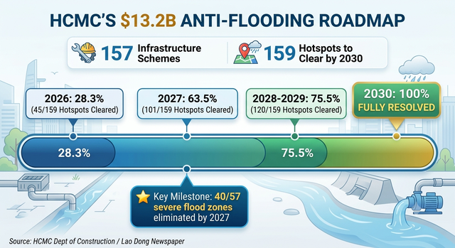
The megaplan is divided into four stages.
Separately, the city has drawn up a 2026 plan to complete 24 flood-control projects costing nearly VND38 trillion ($1.44 billion), expected to address 29 of the 159 flood-prone locations.
The projects include drainage and canal upgrades, water-retention facilities, and tide-control systems.
Beyond individual projects, the city is focusing on repairing drainage facilities, dredging sewers and canals, installing tide-control valves, opening new drainage routes, making better use of pumping stations, and coordinating major tide-control gates to improve protection against high tides.
The city's roadmap aims to shift from responding to flooding after it occurs toward a more comprehensive approach combining infrastructure investment, better planning, and coordinated water management.
In the former Thu Duc City area, now divided into 12 wards in Ho Chi Minh City following the administrative restructuring, authorities are accelerating a series of targeted infrastructure projects to neutralize the area's chronic flooding hotspots.
Near-term relief is expected by the end of 2026, with drainage system upgrades surrounding Thu Duc Market set for completion in September, followed in December by a similar project covering key thoroughfares in the flood-prone Thao Dien hub, including Quoc Huong, Xuan Thuy, and Nguyen Van Huong Streets.
Beyond immediate fixes, municipal authorities have proposed two large-scale engineering interventions budgeted at nearly $300 million for roll-out between 2027 and 2029, according to Lao Dong.
The plan includes a VND2.77 trillion ($105.3 million) project to construct a 1.73-kilometer drainage network along Linh Tay Stream alongside urban road upgrades, and a VND5.08 trillion ($193.2 million) overhaul of Thu Duc Canal featuring a three-kilometer embankment and a high-capacity pumping station capable of discharging 120,000 cubic meters of water per hour.
To further relieve pressure on the low-lying Thu Duc Market basin, the city also plans to complete a VND178 billion ($6.8 million) retention basin at the Linh Tay Sports Center by 2028.








Max: 1500 characters
There are no comments yet. Be the first to comment.