


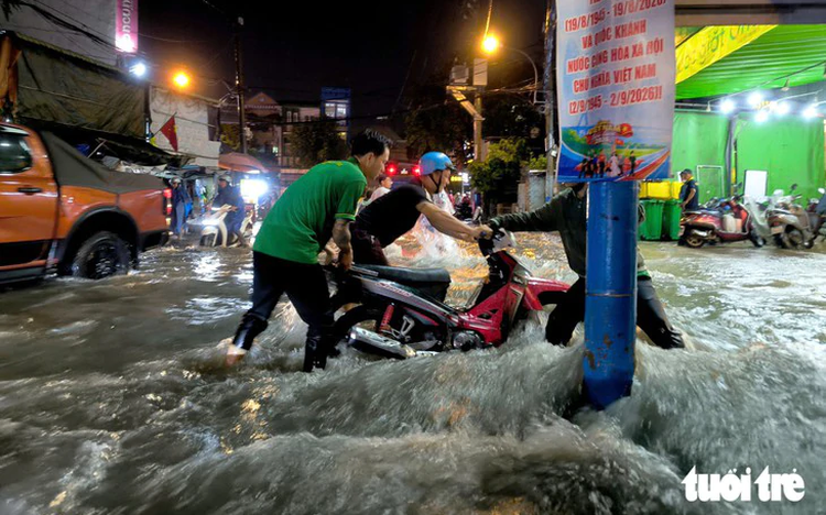
People struggle to make their way through fast-flowing floodwater on Linh Dong Street in Ho Chi Minh City. Photo: Chau Tuan / Tuoi Tre
The city is entering the rainy season, with heavy downpours and high tides causing flooding on many streets, leading to traffic congestion, stalled vehicles and safety risks, according to the police.
To help residents choose suitable routes, the traffic police have identified areas prone to flooding from rain and high tides.
The 83 locations prone to flooding caused by heavy rain include the Bay Hien Intersection, the To Ngoc Van-Linh Dong intersection, the To Ngoc Van-Ly Te Xuyen intersection, Thu Duc Market and a section of Nguyen Van Khoi Street from Le Van Tho Street to the Thong Tay Hoi Ward People's Committee office, and a section of Ma Lo Street from Ma Lo to Huong Lo 2.
The other 39 locations are vulnerable to flooding caused by high tides, including a section of Tran Xuan Soan Street from Huynh Tan Phat Street to Lam Van Ben Street, a section of Nguyen Binh Street from its intersection with Huynh Tan Phat Street to Muong Chuoi Bridge, Pham The Hien Street and R12 Street under Ba Son Bridge.
High tides occur in cycles, so residents should monitor weather forecasts, tide levels and traffic information before setting out, and consider alternative routes or adjusting their travel times to avoid flood-prone areas, the municipal traffic police said.
If they have to travel through a flooded section, road users should assess the water level and respond accordingly.
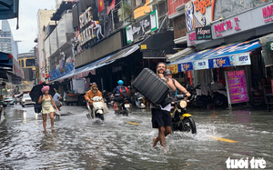
When the water is low, below about 15cm, or below the wheel axle of a motorcycle, and the road surface remains clearly visible, motorists should slow down, maintain a steady throttle and a safe distance, and avoid sudden braking or overtaking.
When the water rises above half the wheel of a motorcycle or approaches the car’s door sill, around 20-30cm, motorists should not attempt to drive through.
Motorcyclists should walk their motorcycles through the area if it is safe to do so or take another route. Car drivers should proceed only when they can clearly assess the water level.
If the water is deep, flowing rapidly or has submerged the road surface, people should never attempt to cross the flooded area and should take another route or wait for the water to recede.
Residents should also watch out for uncovered manholes and submerged obstacles, and stay away from power lines, utility poles, streetlights and advertising signs to avoid the risk of electric shock.
Flooding can also cause traffic congestion, with vehicles moving slowly.
People who need assistance or want to report flooding or traffic congestion can contact traffic police officers on duty or call the municipal traffic police hotline at 0326 08 08 08.
List of 83 flood-prone locations due to heavy rain in Ho Chi Minh City:
Ly Thuong Kiet Street, from No. 387 to the gate of Nguyen Thai Binh High School
Bay Hien Intersection
Le Duc Anh Street - Ho Hoc Lam Street
Provincial Road 10, from Ten Lua Nho to Le Duc Anh
Tran Dai Nghia Street, the branch from No. 4 to the intersection with Le Kha Phieu
Tran Van Giau Street, from No. 55 to the intersection with Vuon Thom
Vinh Loc Street, from Tran Van Giau to Lai Hung Cuong (the section from Tran Van Giau to Ba Tri Bridge is the most severely flooded)
Vo Van Van Street, from No. 700 to No. 730
Le Quang Dao Street:
From the intersection with Vo Thi Hoi to the intersection with Nguyen Thi Soc
Le Quang Dao - Tran Van Muoi intersection
Tran Van Muoi Street, from Le Quang Dao to Xuan Thoi 2
Nguyen Thi Thu Street, from Vo Thi Hoi to Xuan Thoi Son 5
The parallel road to National Highway 22, from Do Muoi to Ba Trieu
Nguyen Anh Thu Street, from Le Quang Dao to Dong Tam
Ba Trieu Street, from the intersection with Quang Trung to the intersection with the parallel road
Trung Nu Vuong Street, from the intersection with Quang Trung to the intersection with Do Van Day
Do Muoi Street:
In front of No. 2539/3A (An Phu Dong Ward)
In front of No. 139 (Tam Binh Ward)
On both sides of Binh Phuoc Bridge, in front of No. 2 (Hiep Binh Ward)
In front of Thu Duc Wholesale Market, at No. 113 (Hiep Binh Ward)
Do Muoi Street - Street 17 intersection
Ben Cat Bridge underpass (Thoi An Ward)
Binh Phuoc Roundabout
Both sides of Binh Phuoc Intersection (under the overpass)
Vo Nguyen Giap Street:
From Trang Bridge to the U-turn point (mixed-traffic lane)
From the U-turn point to Rach Chiec Bridge
The intersection of Vo Truong Toan Street and a parallel road to Vo Nguyen Giap Avenue
Foot of Rach Chiec Bridge, toward Rach Chiec Metro Station (An Khanh Ward)
Mai Chi Tho Street:
To Huu - Mai Chi Tho intersection
Mai Chi Tho - Luong Dinh Cua intersection
From Overpass A toward the intersection with Luong Dinh Cua
To Ngoc Van Street:
Intersection with Pham Van Dong
Intersection with Linh Dong
Intersection with Street 35 (Linh Tay)
Pham Van Dong Street - Linh Dong
No. 69 Trinh Thi Doi Street (Dong Thanh Commune)
Vo Chi Cong Street - Street 5
Thao Dien - Quoc Huong intersection
Do Xuan Hop Street - Tay Hoa
Street 2 (Thu Duc Ward)
Ta Quang Buu Street, from Vo Liem Son to Cao Lo
Thu Duc Market
Ly Te Xuyen Street
Song Than Industrial Park entrance
Provincial Road 743A - My Phuoc Tan Van
Le Van Viet Street, from the intersection with Dinh Phong Phu to the intersection with La Xuan Oai
Nguyen Xien Street, from No. 581 (Vinhomes Grand Park area) to Go Cong Bridge
National Highway 50, from Nguyen Van Linh to Chanh Hung Bridge
Van Tien Dung Street
Nguyen Van Tao Street, from Kenh Lo Bridge to Rach Chim Bridge (Hiep Phuoc Commune)
Nguyen Binh - Le Van Luong intersection (Hiep Phuoc Commune)
Huynh Tan Phat Street - Phu Thuan
Nguyen Van Linh Street:
In front of the Ong Lon Bridge repair project, toward Nguyen Huu Tho from Pham Hung (both SF and SM lanes)
SF lane, from the intersection with Pham Van Nghi to Ca Cam Bridge
D1 Street, from the D1-D6 intersection to the connection with Nguyen Van Linh (including the RMIT underpass)
D6 Street, from Nguyen Huu Tho to the D1-D6 intersection
Hoang Trong Mau Street, from the D6 intersection to D1 Him Lam Bridge
Dang Thuy Tram Street (Binh Loi Trung Ward)
Ung Van Khiem Street, from Nguyen Gia Tri to Dien Bien Phu
Nguyen Van Khoi Street, from Le Van Tho to the Thong Tay Hoi Ward People's Committee office
Pham The Hien Street:
From Alley 2695 to the Le Boi intersection
At the foot of Ba Tang Bridge, in front of No. 2377
Phan Van Khai Street:
No. 534 (Tan An Hoi Commune)
No. 437 (Tan An Hoi Commune)
No. 124 (Cu Chi Commune)
Provincial Road 744:
From the An Tay Elementary School three-way intersection toward An Tay Market
From the Rach Bap three-way intersection toward the beginning of Bung Cong Market
Bui Thanh Khiet Street, from the Nguyen Huu Tri intersection to the Binh Thuan - Cho Dem intersection (Tan Nhut Commune)
Trinh Quang Nghi Street, from Nguyen Van Linh to Ba To Bridge
Ma Lo Street, from Ma Lo to Huong Lo 2
Binh Tri Dong - Chien Luoc Street
National Highway 51:
Km43+300 to Km43+800 (Phu My Ward, direction from Dong Nai to Phu My Ward)
Km44+300 to Km44+600 (Phu My Ward, direction from Dong Nai to Phu My Ward)
Km49+100 to Km49+700 (Tan Phuoc Ward, direction toward Dong Nai)
Km52+300 to Km52+800 (Hoi Bai Intersection, Tan Hai Ward, direction toward Dong Nai)
Km68+900 to Km69+400 (Phuoc Thang Ward, direction from Vung Tau to Ba Ria)
Km73+500 (Eo Ong Tu Intersection, Phuoc Thang Ward, direction from Ba Ria to Vung Tau)
Extended Le Hong Phong Street
Ba Muoi Thang Tu Street, from the oil and gas port to Thang Nhat Market
Hai Thang Chin Street
Nguyen An Ninh Street
Truong Cong Dinh Street
Nguyen Tat Thanh Street (Long Hai Commune)
List of 39 flood-prone locations due to high tides in Ho Chi Minh City:
Le Kha Phieu Street:
Parallel road, direction from Hung Nhon to Duong Dinh Cuc
Hoang Dao Thuy intersection, direction from Nguyen Van Linh toward Binh Dien Bridge
Ben Nghe Street, No. 4 (Tan Thuan)
Tran Xuan Soan Street, from Huynh Tan Phat to Lam Van Ben
Nguyen Thi Thap Street:
Nguyen Thi Thap - Tan My intersection
Nguyen Thi Thap - Le Van Luong intersection
Le Van Luong Street:
The section through Nha Be Commune
About 250m before the Rach Tom Bridge construction project, direction from Ho Chi Minh City to Tay Ninh
Huynh Tan Phat Street:
Intersection with Pham Huu Lau
Intersection with Hoang Quoc Viet
Nguyen Luong Bang Street:
Intersection with Hoang Quoc Viet, direction from Pham Huu Lau toward Nguyen Luong Bang
Intersection with Pham Huu Lau
Pham Huu Lau Street, from the intersection with Huynh Tan Phat to Phuoc Long Bridge
Nguyen Huu Tho Street, from the intersection with Pham Huu Lau to Rach Dia 2 Bridge (direction from Nha Be Commune toward the city center)
Nguyen Binh Street, from the intersection with Huynh Tan Phat to Muong Chuoi Bridge
Le Thi Tam Street (Hiep Phuoc Commune)
Nguyen Van Quy Street, on both sides of Phu My Bridge
Go Cong Street
Phan Phu Tien Street
Vo Van Kiet Street, from Pham Phu Thu to Binh Tien
Pham Phu Thu Street, from Vo Van Kiet to Pham Van Chi
Song Hanh Lon Street (Binh Phu Ward)
Tran Van Kieu - Street 32 intersection
Foot of Lo Gom Bridge
Mai Xuan Thuong Street
Cao Dat Street
An Binh Street
Nguyen Bieu Street
Tran Hung Dao Street, from Nguyen Bieu to Nguyen Tri Phuong
Pham The Hien Street
Duong Ba Trac Street
Foot of Rach Chiec Bridge, direction from Vo Nguyen Giap toward RMK (motorcycle lane)
Mai Chi Tho Street, in front of New City Apartment Building
R12 Street, under the foot of Ba Son Bridge
Nguyen Van Huong Street
Nguyen Duy Trinh Street, Kim Long 813 gas station (Long Truong Ward)
Lien Phuong - Bung Ong Thoan intersection
Embankment at Lot F, Thanh Da Residential Area (Binh Quoi Ward)
Ha Huy Giap Street (An Phu Dong Ward)


Max: 1500 characters
There are no comments yet. Be the first to comment.