
Northern Vietnam braces for heavy rain as tropical depression brings strong winds
Northern Vietnam is forecast to see widespread heavy rain through Thursday as a tropical depression moves westward over the East Vietnam Sea, while strong winds are expected in the northern waters, according to the National Center for Hydro-Meteorological Forecasting.
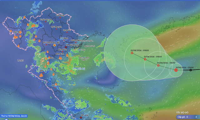
The forecast position and track of the tropical depression on August 19, 2026. Photo: Vietnam Disaster Management System
The depression was about 400 kilometers east of China's Hainan Island early on Wednesday, with winds near its center reaching 39-49 kilometers per hour and gusts reaching level eight.
It is forecast to move west-northwest at about five kilometers per hour through Thursday, with little chance of strengthening, before heading toward the waters east of China's Leizhou Peninsula.
The northern East Vietnam Sea is expected to see winds reaching level six and gusting to level eight, with waves of 2-3.5 meters.
Vessels in the affected waters face risks from thunderstorms, waterspouts, strong winds, and high waves.
Tran Nhu Quynh, a forecaster at the National Center for Hydro-Meteorological Forecasting, said a tropical convergence zone over northern Vietnam, combined with strengthening upper-level winds at up to 5,000 meters, would bring heavy rain to northern and north-central Vietnam through Friday.
The Red River Delta, southern Phu Tho Province, and the areas from Thanh Hoa to northern Quang Tri are forecast to receive 70-150 mm of rain from Wednesday through Thursday, with isolated areas exceeding 200 mm.
The northern midlands could receive 40-80 mm, with isolated rainfall above 160 mm.
Southern Quang Tri and Hue City are forecast to receive 30-60 mm, with isolated areas exceeding 100 mm, while mountainous areas in northern Vietnam could see 20-40 mm, with isolated rainfall above 80 mm.
The Central Highlands and southern Vietnam are also forecast to see showers and thunderstorms on Wednesday afternoon and night, with 15-30 mm of rain and isolated areas receiving more than 70mm.
Residents should prepare for flooding in low-lying areas, urban and industrial zones, as well as flash floods and landslides in mountainous areas.
The Ky - Chi Tue / Tuoi Tre News
Link nội dung: https://news.tuoitre.vn/northern-vietnam-braces-for-heavy-rain-as-tropical-depression-brings-strong-winds-103260819092748827.htm