Rare weather phenomenon: Unusual tropical depression near equator moves toward storm Koto in East Vietnam Sea
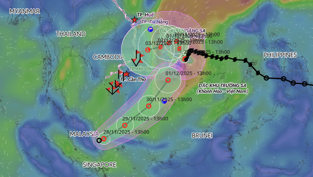
A rare tropical depression near the equator off Malaysia’s east coast is expected to enter the southwestern part of the southern East Vietnam Sea and move toward storm Koto, Vietnam’s weather agency said on Friday.

A forecast map shows the projected path of storm Koto and a nearby tropical depression near the southern part of the East Vietnam Sea. Photo: Vietnam’s National Center for Hydro-Meteorological Forecasting
The National Center for Hydro-Meteorological Forecasting (NCHMF) said the system had maximum sustained winds of 39–61 kph at 1:00 pm, with gusts up to level 9.
It is forecast to move northeast at about 15 kph and reach the southern East Vietnam Sea on Saturday.
The agency said little strengthening is expected.
By Sunday afternoon, the depression is expected to maintain winds at level 7 with gusts to level 9 before weakening as it turns north-northeast at about 15 kph.
NCHMF warned of rough seas, with winds at level 6–7 and gusts to level 9 and waves of 2.5–4 m in the southwestern portion of the southern East Vietnam Sea.
Storm Koto weakens slightly
At 1:00 pm on Friday, storm Koto was about 190 km northwest of Vietnam’s Song Tu Tay Island with maximum sustained winds of level 10 and gusts to level 13, down one wind level from earlier, the agency said.
The storm, the 15th to hit the East Vietnam Sea this year, was moving west-southwest at about 5 kph.
NCHMF director Mai Van Khiem said Koto may shift direction several times over the next three days — north on Saturday, west on Sunday, and west-southwest next Monday.
He said the storm may weaken by one level each day and could downgrade to a tropical depression as it approaches waters off Quang Ngai and Dak Lak Provinces.
The agency warned of strong monsoon-enhanced winds across the East Vietnam Sea, including waves of 5–7 m in Vietnam's Hoang Sa (Paracel) Special Zone and up to 9 m near the storm’s center in central waters.
Bao Anh - Chi Tue / Tuoi Tre News
