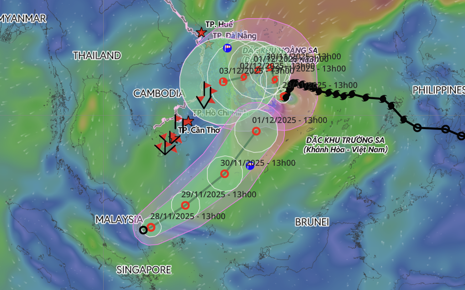
Storm Koto drifts slowly as rare tropical depression moves into East Vietnam Sea
Storm Koto has been weakening and drifting slowly from Saturday morning, while a rare tropical depression east of Malaysia has been moving toward the southern East Vietnam Sea, according to the National Center for Hydro-Meteorological Forecasting.
At 4:00 am on Saturday, the center of Koto, the 15th storm to affect the East Vietnam Sea this year, was located about 310 kilometers northwest of Song Tu Tay Island in Vietnam’s Truong Sa Special Zone.
The storm, weakening from the previous day, produced sustained winds of up to 102 kph, with gusts reaching 133 kph, and was moving north-northwest at 5–10 kph.
Forecasters said Koto would continue drifting north over the next 24 hours with little change in strength.
By 4:00 am on Sunday, its center is projected to be about 330 kilometers east of the coastal area off Gia Lai and Dak Lak, carrying winds of 75–102 kph and gusts of up to 149 kph.
Between 24 and 48 hours from now, the storm is expected to shift westward and gradually weaken.
By 4:00 am on Monday, the storm’s center is expected to be about 300 kilometers east of the same coastal region, with winds reduced to around 88 kph and gusts of 133 kph.
Afterward, Koto is forecast to move west-southwest at only 3–5 kph while continuing to weaken.
By 4:00 am on Tuesday, the storm is expected to be about 230 kilometers east of the offshore area of Gia Lai–Dak Lak, with winds remaining at weakened levels.
The forecast center said the storm is likely to weaken into a tropical depression as it approaches the waters off Quang Ngai and Dak Lak in the coming days.
Strong winds and rough seas are expected across the central East Vietnam Sea over the next three days.
Near the storm’s center, winds may reach up to 117 kph, with gusts of 166 kph, generating waves seven to nine meters high and extremely rough conditions.
Offshore areas from Gia Lai to Khanh Hoa may experience winds strengthening to 49–74 kph, gusting up to 102 kph, with waves up to six meters high.
Vessels operating in these areas could encounter thunderstorms, squalls, strong winds, and large waves.
Meanwhile, the tropical depression east of Malaysia was moving northeast at about 15 kph early on Saturday, with winds of 39–61 kph and gusts up to 88 kph.
It is forecast to enter the southern East Vietnam Sea on Saturday morning, meaning both Koto and the tropical depression could be active simultaneously.
After entering the sea, the depression is expected to turn northeast toward waters off the southern and south-central provinces.
Forecasters said it is unlikely to directly impact southern coastal areas on land.
Instead, its circulation will mainly generate strong winds and rough seas over the western part of the southern East Vietnam Sea, including waters west of Vietnam's Truong Sa (Spratly) Special Zone and the eastern waters from Lam Dong to Ca Mau.
Historical data since 1951 show that several tropical depressions have formed at latitudes below five degrees north, like the depression east of Malaysia, but most have moved westward rather than eastward, according to the forecasting center.
Mai Van Khiem, the center’s director, said the current depression is ‘extremely rare, or perhaps unprecedented.’
Vinh Tho – Chi Tue / Tuoi Tre News
Link nội dung: https://news.tuoitre.vn/storm-koto-drifts-slowly-as-rare-tropical-depression-moves-into-east-vietnam-sea-103251129112212309.htm
