Storm Matmo races toward northern Vietnam, landfall expected early next week
Storm Matmo is intensifying over the East Vietnam Sea and could reach level-13 strength on the Beaufort wind scale with gusts at level 16 (184-201 kph) before making landfall in northern Vietnam early on Monday, according to the national weather agency.
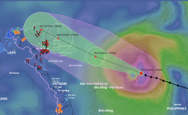
A satellite image shows storm Matmo's projected path as recorded at 7:00 am on October 4, 2025. Photo: Vietnam Disaster Monitoring System
At 9:00 am on Saturday, Matmo’s center was located about 450 kilometers east-northeast of Vietnam’s Hoang Sa (Paracel) Special Zone, packing sustained winds of 103-117 kph with gusts up to 150-166 kph.
Matmo, the 11th storm to enter the East Vietnam Sea this year, was moving quickly northwest at around 25 kph.
The National Center for Hydro-Meteorological Forecasting predicted the storm could intensify further, reaching sustained winds of 134-149 kph and gusts up to 184-201 kph within 24 hours.
It is expected to enter the Gulf of Tonkin on Sunday and strike the northeastern provinces around dawn on Monday.
The agency noted that the extent of weakening as the storm approaches land will depend on its track.
A more northerly route would push Matmo inland sooner, reducing intensity by two to four levels.
A westward path over open waters would mean stronger winds and heavier rainfall.
Strong winds of 62-102 kph are forecast for the northern East Vietnam Sea, increasing to 103-149 kph near the storm’s center, with waves up to eight meters and extremely rough seas.
From Sunday afternoon, the eastern Gulf of Tonkin, including Bach Long Vi Special Zone, will possibly see winds at 39-61 kph and later at 62-88 kph.
By the evening, the northern Gulf of Tonkin, covering Van Don, Co To, Cat Hai Special Zones and Hon Dau Island, may face winds at 62-88 kph, gusting to 150-166 kph, with waves up to five meters.


Along the coast, storm surge is expected to raise sea levels by 0.4-0.6 meters in Quang Ninh Province and Hai Phong City, increasing the risk of flooding in low-lying estuaries and coastal zones.
Onshore, winds in Quang Ninh to Ninh Binh Provinces are forecast to strengthen to 75-102 kph, capable of toppling trees, damaging homes, and downing power lines.
Inland areas of the northeast could still see gusts at 62-88 kph.
Heavy rain is expected across northern Vietnam, Thanh Hoa, and Nghe An from Sunday night through Tuesday next week, with totals of 100-200 millimeters, locally over 300 millimeters.
Mountainous and midland areas may receive 150-250 millimeters, with isolated spots exceeding 400 millimeters, raising the risk of flash floods, landslides, and urban flooding.
Minh Duy - Chi Tue / Tuoi Tre News
Link nội dung: https://news.tuoitre.vn/storm-matmo-races-toward-northern-vietnam-landfall-expected-early-next-week-10325100410562983.htm