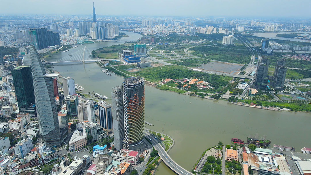
With proper planning and organization, the Saigon River has the potential to transform into a river of immense historical, cultural, heritage, and economic value, spurring the development of HCMC and crafting a distinctive identity for the city.
After nearly 40 years of rapid urban development, the once-vast land resources of HCMC have been significantly used up, leaving only Can Gio and Cu Chi districts as relatively untouched areas. Surprisingly, a stretch of land approximately 80 kilometers long along the Saigon River has remained largely untouched and in its natural state. Perhaps it is due to the oversight of real estate magnates, or maybe the true potential of this land is still hidden beneath layers of geography, culture, and history, which the hesitant have yet to explore. Regardless of the reason, this represents a fortunate and valuable asset for the city. With careful planning and development, this area has the potential to transform into a river rich in historical, cultural, heritage, and economic significance – often referred to as the “money river.” Such a transformation would undoubtedly contribute to the growth and identity of HCMC.
Many of the world’s major and renowned cities are intricately linked with rivers because rivers are an essential source of life. They provide drinking water, support agriculture and livestock, and offer valuable resources such as alluvial soil, aquatic products, fish, a means of waterborne transportation, and clean air. Paris boasts the Seine River, London is synonymous with the Thames River, Moscow thrives along the Moscow River, Bangkok is defined by the Chao Phraya River, and Shanghai is intertwined with the Huangpu River. In Vietnam, the Red River is deeply connected with Hanoi, the Huong River with Hue, the Han River with Danang, the Hau River with Can Tho, and the Saigon River with HCMC. Each of these rivers holds unique value and beauty, but among them, the Saigon River stands out as an invaluable gift from nature to the city.
The Saigon River, a tributary of the Dong Nai River, is unique among Vietnam’s major rivers, as it originates entirely within the country’s borders. Stretching 256 kilometers in length, it flows through the provinces of Binh Phuoc, Tay Ninh, Binh Duong, and ultimately reaches HCMC. Within HCMC, it covers a distance of 80 kilometers, and has an average flow rate of approximately 54 cubic meters per second, a width ranging from 225 to 370 meters, depths of up to 20 meters in certain areas, and a basin area exceeding 5,000 square kilometers.
Throughout the history of Saigon, its residents have relied on the Saigon River for sustenance and livelihoods. Today, the Saigon Water Corporation (Sawaco) supplies a daily volume of 2.4 million cubic meters of clean water for various purposes, with 90% of this water sourced from the Saigon and Dong Nai rivers. Notably, the Saigon River maintains a consistent flow, never drying up entirely, even during dry season, albeit with reduced water levels. Due to its relatively narrow riverbed, the flow remains forceful enough to carry away waste, water ferns, industrial effluents, and domestic sewage towards the sea, helping to maintain its cleanliness.
Moreover, the Saigon River contains less sediment than other rivers like the Red, Tien, and Hau. While Hanoi sits alongside the Red River, it no longer uses water from the river directly due to its high sediment content, instead opting for water from the Da River, located hundreds of kilometers away. Unlike the Red River, which once experienced frequent flooding, the Saigon River now remains stable, rendering the certain river embankments redundant. Occasionally, water levels near the riverbed become shallow enough for people to wade across. However, as the Saigon River is developed in the future, it is crucial to preserve its cleanliness. This river serves as the sole, irreplaceable water source for more than 10 million city residents.
The Saigon River stands out as one of Vietnam’s most picturesque rivers, possibly even in the entire region. Unlike many other rivers in Vietnamese cities, such as the Tien and Hau, or those in Southeast Asian urban centers like the Chao Phraya in Bangkok, the Pasig in Manila, and the Tonle Sap in Phnom Penh, the Saigon River boasts a distinct and captivating shape. When viewed from above, this river meanders gracefully, resembling a flowing expanse of soft green silk adorned with numerous bends and curves that create scenic promontories. These distinctive curves are often referred to as “camel humps” and can be observed in areas such as the Cu Chi Tunnels, An Nhon Tay, Van Phuc City, Thanh Da, Thao Dien, and Thu Thiem.
The downstream of the Saigon River, as it courses through HCMC, exudes a tranquil and gentle charm. The riverbanks are situated on relatively unstable soil foundations, with many areas having alluvial soil that is susceptible to sinking. Additionally, there are numerous underground water sources, water pockets, and layers of sediment beneath these areas. Consequently, any spatial organization and urban design must be approached with caution. The construction of heavy structures like expressways, high-rise buildings, and extensive interconnected streets could lead to soil subsidence or even ruptures. Building solid embankments might alter the river’s course, potentially causing erosion and the gradual disappearance of prominent areas like Thanh Da, Thu Thiem, Thao Dien, and Nha Rong.
The Saigon River flows over 80 kilometers through HCMC, stretching from the northernmost point in Phu My Hung Commune, Cu Chi District, to its southern terminus in District 7, where it joins the Soai Rap River. This river serves as the city’s welcoming façade, bookended by two distinct forests. The northern starting point boasts a combination of natural and regenerated forests in Cu Chi District, while the southern end leads to the mangrove forest in Can Gio District. The latter has been recognized as a UNESCO World Biosphere Reserve, emphasizing the Saigon River’s critical role in climate regulation.
Recognizing the Saigon River’s significance in climate regulation, urban planners and designers have held it in high regard for nearly a century. Under French colonial rule and later under the Republic of Vietnam regime, construction projects in areas like Bach Dang (District 1) and Khanh Hoi (District 4), as well as in Binh Thanh District after 1954, adhered to the principle of keeping structures low on the riverbanks while maintaining height within the buildings themselves.
Historical architectural treasures, public buildings, and hotels in the city were limited to just two stories and intentionally disconnected to facilitate wind and light from the river, particularly the warm sea breeze. All main roads were designed to lead straight to the river ports, like Bach Dang and Khanh Hoi, to capture the wind and serve as conduits for the refreshing river breezes into the city. Some of these significant roads include Nguyen Binh Khiem, Ton Duc Thang, Hai Ba Trung, Dong Khoi, Nguyen Hue, Ham Nghi, Doan Nhu Hai, and Hoang Dieu.
Another remarkable feature of the Saigon River is its rich heritage and cultural value. Along the river’s banks, numerous historical and architectural gems are scattered, with a concentration in District 1, as well as parts of District 4 and Binh Thanh District. These include Nha Rong Wharf, the iconic water tower, the Thu Ngu Flag Pole, the Customs House, the Riverside Hotel, the Majestic Hotel, the Ton Duc Thang Museum, the Tran Hung Dao Statue, the Ba Son Shipyard, the riverside park, and the Saigon Bridge, all of which are over a century old. Additionally, the river hosts landmarks such as the Binh Loi Bridge, the Binh Trieu Bridge, and at its northern terminus, the Cu Chi Tunnels and the Ben Duoc Memorial. Along this stretch of the river, you will also find pagodas, temples, traditional southern houses, and vibrant craft villages, including those specializing in flowers, ornamental trees, eco-farming, knitting, and rice paper.
We are the stewards of a riverfront space along the Saigon River, which holds immense value, not only in terms of its scenic beauty and physical attributes but also its spiritual significance, encompassing a wealth of heritage, architecture, and cultural structures. Part of this precious inheritance is a gift from nature, while the rest has been painstakingly created by generations of city residents. The riverbanks represent one of the last remaining stretches of open land in the city center. Therefore, we must exercise great caution in any plans for its development. Any misguided actions regarding the Saigon River would come at a high cost and be a disservice to future generations.
(*) Former Dean of the Urban Study Department, University of Social Sciences and Humanities, Vietnam National University, HCMC