
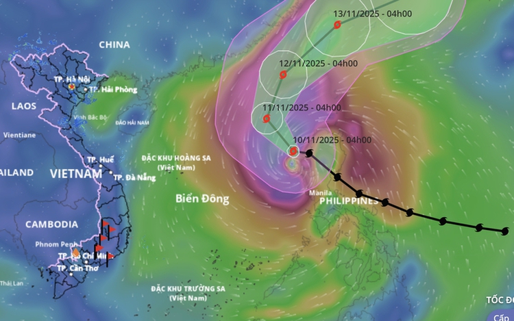
A map shows the projected path of storm Fung Wong, as recorded at 4:00 am on November 10, 2025. Photo: Vietnam’s National Center for Hydro-Meteorological Forecasting
As of 4:00 am Monday, the storm — the 14th to form in the sea region this year — was located over the northeastern part of the East Vietnam Sea, with maximum sustained winds of 134–149 kph and gusts up to 201 kph near its center.
Throughout Monday, Fung Wong is forecast to move northwest at about 15 kph with little change in intensity.
By 4:00 am Tuesday, its center will still be over the northeastern waters of the East Vietnam Sea with similar strength before turning north-northeast at 10–15 kph.
Meteorologists explained that the weakening of a subtropical high ridge to the north has caused the storm to shift slightly northward.
As it moves to higher latitudes, Fung Wong is expected to come under the influence of upper-level westerly winds, which will likely steer it northeastward and steadily out of the East Vietnam Sea.
By 4:00 am Wednesday, the storm is expected to be over the far northeastern waters of the East Vietnam Sea, maintaining maximum winds of around 149 kph and gusts up to 201 kph, before moving toward Taiwan and gradually weakening.
Forecasters noted that late-season storms usually travel west or west-southwest and often make landfall in central or south-central Vietnam.
Fung Wong’s northward and outward track is therefore considered unusual and poses no threat to the mainland.
Under the storm’s influence, the northeastern part of the East Vietnam Sea is experiencing strong winds of 62–88 kph, increasing to 103–149 kph near the center, with gusts reaching 201 kph.
Waves are reported at 5–8 meters high, rising to 8–10 meters near the storm’s core, creating very rough seas.
All vessels operating in these dangerous areas have been advised to remain alert to possible thunderstorms, whirlwinds, powerful winds, and high waves.

Max: 1500 characters
There are no comments yet. Be the first to comment.