
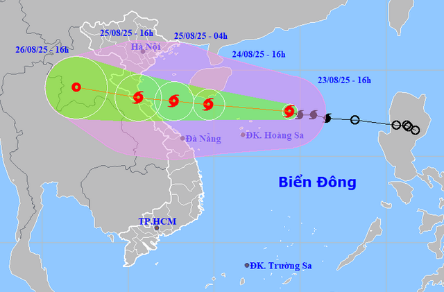
A map shows the projected locations and path of storm Kijiki, the fifth storm to hit the East Vietnam Sea in 2025, as of 4:00 pm on August 23, 2025. Photo: Vietnam’s National Center for Hydro-Meteorological Forecasting
At 4:00 pm on Saturday, Kajiki’s center was located about 230 kilometers east-northeast of Vietnam’s Hoang Sa (Paracel) special zone, with maximum sustained winds at level 9-10 (75-102 kph) on the Beaufort scale and gusts at level 12 (118-133 kph).
In the next 24 hours, the system may move west-northwest at 20-25 kph and intensify further.
By 4:00 pm on Sunday, its center could be in the southern waters of China’s Hainan Island, packing winds at level 12 and gusts at level 14 (150-166 kph).
By 4:00 am on Monday, Kajiki is forecast to be in the waters from Thanh Hoa to Quang Tri, with maximum sustained winds at level 13 (134-149 kph) and gusts at level 15 (167-183 kph).
It is anticipated to make landfall in the Thanh Hoa-Quang Tri area on Monday afternoon.
Nguyen Van Huong, head of the center’s weather forecasting department, warned that favorable sea surface temperatures of around 30 degrees Celsius, low wind shear, and converging airflows are fueling its rapid intensification.
He said foreign agencies are predicting severe scenarios.
China forecasts peak winds at level 13 (134-149 kph) affecting Ha Tinh to Quang Tri Provinces in central Vietnam.
Meanwhile, Japan estimates maximum sustained winds at level 12 (118-133 kph).
Huong said that Kajiki was moving unusually fast, at 25-30 kph.
“That means within one or two days, starting Sunday evening, strong winds and heavy rains may directly impact Vietnam’s mainland,” he warned.
Even before its landfall, storm clouds may trigger thunderstorms and squalls in waters from Quang Ninh Province to Da Nang City, hundreds of kilometers away.
He emphasized that Kajiki’s fast track and potential for rapid intensification mean communities in northern and central Vietnamese provinces must monitor forecasts closely and prepare for severe impacts.
The national weather center warned of extreme rainfall of 150-300 millimeters from Thanh Hoa to Hue City, with some areas exceeding 600 millimeters.
The northern delta, including Hanoi, is expected to see heavy rains from August 25 to 27.
The storm could trigger flash floods, landslides, and severe urban flooding.
In southern Vietnam, the southwest monsoon is strengthening due to Kajiki’s circulation.
From August 24-26, Ho Chi Minh City and other southern provinces will experience frequent downpours and thunderstorms, with risks of flooding in low-lying areas and severe lightning, hail, and strong gusts.

Max: 1500 characters
There are no comments yet. Be the first to comment.