
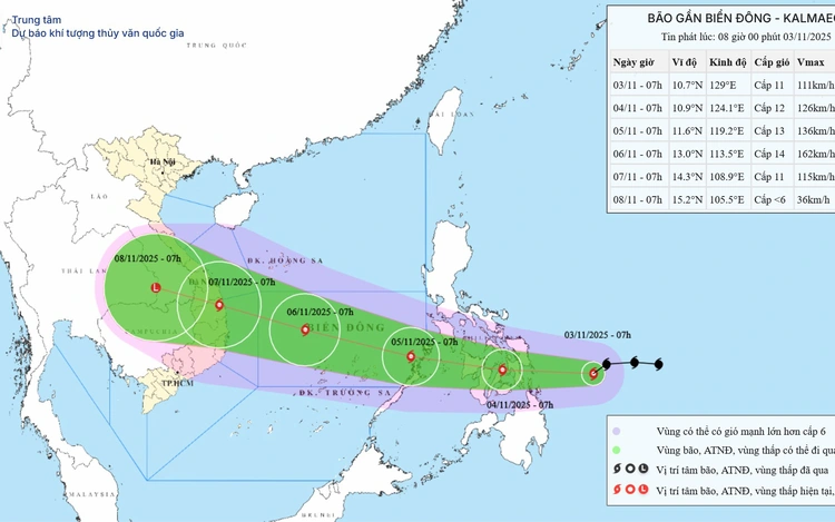
A map shows the projected path of storm Kalmaegi, as recorded at 7:00 am on November 3, 2025. Photo: Vietnam’s National Center for Hydro-Meteorological Forecasting
As of 7:00 am on Monday, the storm’s center was located over the waters east of the central Philippines, packing maximum sustained winds of 89–102 kph, with gusts up to 183 kph — stronger than the 133 kph recorded at 4:00 pm on Sunday.
The storm was moving west-southwest at around 25 kph.
Over the next 24 hours, Kalmaegi is expected to move mainly westward at about 20 kph and continue strengthening as it approaches the Philippines.
By 7:00 am on Tuesday, the storm’s center is forecast to be over the central Philippines.
Around early Wednesday morning, Kalmaegi is expected to enter the East Vietnam Sea, becoming the 13th storm to form in the area this year.
After entering the sea, it will move west-northwest at 20–25 kph and continue to intensify.
By 7:00 am on Thursday, its center will be over the central East Vietnam Sea, with sustained winds of 134–149 kph and gusts up to 220 kph.
About 24 hours later, the storm’s center is expected to be around 430 kilometers east-southeast of Gia Lai Province in Vietnam’s Central Highlands, with winds of 150–166 kph and gusts up to 220 kph.
Kalmaegi will then move west-northwest toward the mainland at about 20 kph, potentially affecting central provinces directly.
Over the next 72 hours, the storm is expected to maintain both its direction and intensity before gradually weakening.
Meteorologists forecast that Kalmaegi could make landfall in Vietnam around Friday, with areas from Da Nang to Khanh Hoa likely to be the hardest hit.
The storm is expected to bring strong winds and heavy rain to the central and south-central regions, as well as the Central Highlands, from Thursday night through Sunday.
Starting Tuesday afternoon, the eastern part of the central East Vietnam Sea is forecast to experience winds of 49–88 kph, increasing to 133 kph near the storm’s center, with gusts of 150–183 kph and rough seas with waves 5–7 meters high.
Between Wednesday and Thursday, the central East Vietnam Sea — including Vietnam's Truong Sa (Spratly) Special Zone and the offshore areas from Da Nang to Khanh Hoa — may face winds of 118–166 kph, gusts over 220 kph, and waves reaching 8–10 meters amid extremely rough sea conditions.
All vessels and offshore facilities in the affected areas are advised about extremely dangerous weather with thunderstorms, gales, and violent seas.

Max: 1500 characters
There are no comments yet. Be the first to comment.