
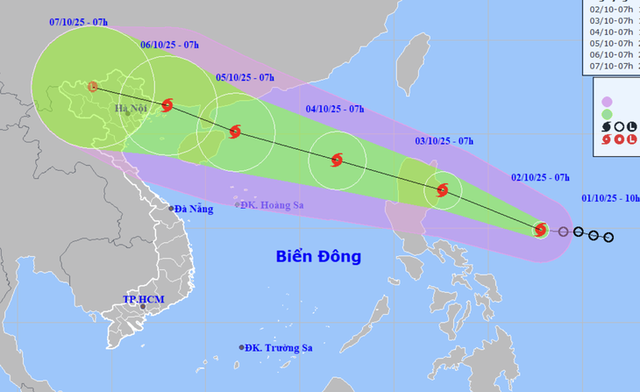
A map shows the projected path of storm Matmo, as recorded at 7:00 am on October 2, 2025. Photo: Vietnam’s National Center for Hydro-Meteorological Forecasting
At 7:00 am on Thursday, Matmo’s center was located over waters east of the Philippines, packing maximum sustained winds of 62-74 kph, gusting to 90 kph.
Over the next 24 hours, the storm is expected to move west-northwest at 20-25 kph and intensify further.
By 7:00 am on Friday, Matmo is predicted to reach the eastern coast of Luzon Island, with sustained winds of 75-88 kph and gusts up to 103-117 kph.
It will then cross Luzon and move into the East Vietnam Sea in the evening, likely becoming the 11th storm to enter the maritime region this year.

At 7:00 am on Saturday, the storm’s center is forecast to be about 550 km east-northeast of Vietnam’s Hoang Sa (Paracel) Special Zone, sustaining winds of 89-102 kph, gusting to 118-133 kph.
Within 72 hours, it is expected to move west-northwest at about 25 kph, strengthening further.
By Sunday, Matmo’s center could be just 70 km northeast of Hainan Island, China, with sustained winds of 118-133 kph and gusts up to 167-183 kph.
The national weather agency warned the storm may intensify to level 12 (118-133 kph) on the Beaufort scale, potentially entering the Gulf of Tonkin and impacting Vietnam’s northern coast.
From Friday afternoon, the northern East Vietnam Sea may experience winds of 39-61 kph, increasing to 62-88 kph near the storm’s path, with gusts up to 118 kph. Waves may reach four to six meters, resulting in very rough seas.
Between Saturday and Monday, the Hoang Sa area could see winds of 103-133 kph, gusting to 167-183 kph.
Authorities have advised vessels operating in affected areas to take precautions against strong winds, rough seas, and thunderstorms.

Max: 1500 characters
There are no comments yet. Be the first to comment.