
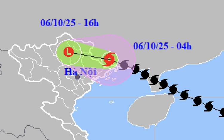
A map shows the projected path of storm Matmo, as recorded at 4:00 am on October 6, 2025. Photo: Vietnam’s National Center for Hydro-Meteorological Forecasting
As of 5:00 am, a few hours after its landfall, Matmo weakened to sustained winds of 62–74 kph and maximum gusts reaching 102 kph.
The storm is forecast to continue moving west-northwest at around 20 kph, gradually weakening as it moves deeper into northern Vietnam before turning into a tropical depression and then a low-pressure system.
Under the storm’s circulation, the northern Gulf of Tonkin, including the Bach Long Vi, Van Don, and Co To islands, has experienced strong winds of 62–74 kph, squalls of up to 102 kph, and rough seas with waves rising to 2–3 meters.
Onshore winds in Quang Ninh and Lang Son Provinces reached 61 kph, with maximum gusts of 88 kph.
From early Monday through Tuesday night, the northern mountainous and midland regions are expected to receive heavy rainfall of 100–200 mm, with some areas getting up to 300 mm.
Localized downpours of over 150 mm within three hours could trigger flash floods and landslides.
In Hanoi, winds are expected to remain mild, but moderate to heavy rain of 50–100 mm, locally over 150 mm, will likely cover the capital city from Monday noon through the end of Tuesday.
The northern delta and Thanh Hoa Province are forecast to see moderate to heavy rain of 50–150 mm, with some places exceeding 200 mm.
The meteorological agency has warned of possible thunderstorms, whirlwinds, and strong gusts during heavy rains.
From Monday through Thursday, river levels in northern Vietnam and Thanh Hoa may rise by four to eight meters upstream and two to five meters downstream, potentially causing flooding in low-lying and urban areas.

Max: 1500 characters
There are no comments yet. Be the first to comment.