


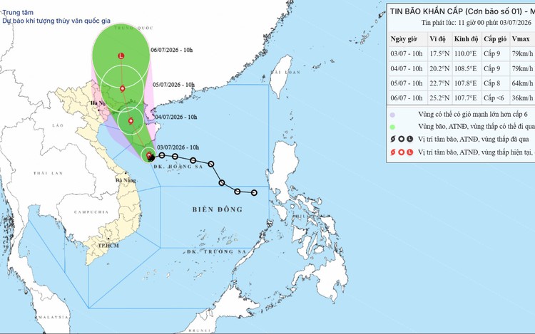
A map shows the projected path of tropical storm Maysak over the East Vietnam Sea, as recorded at 7:00 am on July 3, 2026. Photo: Vietnam’s National Center for Hydro-Meteorological Forecasting
At 7:00 am on Friday, the storm was centered over waters northwest of Vietnam’s Hoang Sa Special Zone, about 140 kilometers southeast of China's Hainan Island, and was moving slowly west-northwest at about 5 kph.
Maximum sustained winds near the eye of the storm were 62-74 kph, with gusts reaching 102 kph.
Over the next 24 hours, Maysak is forecast to move northwest at 10-15 kph and make landfall on Hainan Island.
By 1:00 am on Saturday, the storm is expected to be over the eastern Gulf of Tonkin, with sustained winds of 74 kph and gusts of up to 102 kph.
The storm is forecast to continue moving northwest at a similar speed throughout Saturday, heading toward the waters off Quang Ninh Province and Hai Phong City.
By 1:00 am on Sunday, the storm's center is expected to be over waters off the Quang Ninh–Hai Phong coast, maintaining the same intensity.
Forecasters said Maysak could move inland between Quang Ninh in Vietnam and Guangxi in China later on Sunday morning before weakening into a tropical depression and eventually a low-pressure area.
The weather agency warned that the western part of the northern East Vietnam Sea, including Vietnam’s Hoang Sa Special Zone, will experience winds of up to 74 kph, with gusts reaching 102 kph.
Wave heights are forecast at two to five meters, creating very rough sea conditions.
From Friday night, the Gulf of Tonkin is expected to experience winds of up to 74 kph, with gusts reaching 102 kph.
Waves in the gulf are forecast at two to four meters, with rough seas expected.
Along the coast from Quang Ninh to Hung Yen Provinces, waves are forecast to reach two to three meters, while storm surge could raise sea levels by 0.2-0.3 meters.
“Fishing vessels, floating fish farms, aquaculture facilities, sea dikes, coastal embankments, and coastal roads within the storm's danger zone are likely to be affected. Boats and other marine structures face a high risk of capsizing, damage, and flooding due to strong winds, thunderstorms, tornadoes, large waves, and storm surge,” the weather agency said.
From Saturday afternoon, the coastal areas from Quang Ninh to Hung Yen are expected to experience sustained winds of up to 74 kph, with gusts reaching 102 kph.
Farther inland across northeastern Vietnam, winds are forecast to reach up to 28 kph, with gusts of up to 74 kph, while thunderstorms, tornadoes, and damaging squalls remain possible.
From Friday night through Sunday, northeastern Vietnam and north-central Thanh Hoa Province are expected to receive widespread rainfall totaling 100-200 mm, with isolated areas receiving more than 350 mm.








Max: 1500 characters
There are no comments yet. Be the first to comment.