
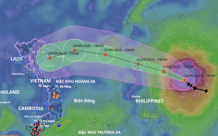
A map shows the projected locations and path of storm Ragasa, as recorded at 7:00 pm on September 20, 2025. Photo: Vietnam Disaster Monitoring System
At 7:00 pm, the storm's center was located approximately 650 km east of Luzon Island off the Philippines.
After entering the East Vietnam Sea, the storm will move quickly toward the coast of Guangdong Province in China, then change direction toward the Leizhou Peninsula in China before entering the Gulf of Tonkin.
Current forecasts indicate that Ragasa is likely to directly impact Vietnam’s mainland.
Over the next 24 hours, the storm is projected to move west-northwest at a speed of around 15 km/h and continue to strengthen.
By 7:00 pm on Sunday, it is forecast to be about 340 km east of Luzon, with sustained winds of level 14–15 (150–183 km/h) and gusts exceeding level 17.
In the next 24 to 48 hours, Ragasa is expected to maintain a west-northwestward track at 15–20 km/h and potentially intensify into a super typhoon.
By 7:00 pm on Monday, the center of the storm will be over the northern waters of Luzon Island, with sustained winds at level 16 and gusts over level 17.
In the following 48 to 72 hours, the super typhoon will continue west-northwestward at 20–25 km/h, entering the East Vietnam Sea.
It is likely to become the ninth storm to hit the East Vietnam Sea this year and the first super typhoon to form in the maritime area in this storm season.
By 7:00 pm on Tuesday, Ragasa’s center will be in the northeastern part of the northern East Vietnam Sea, approximately 270 km southeast of Hong Kong, maintaining strength at level 16 with gusts over level 17.
Between 72 and 120 hours ahead, the storm will move west-northwest, then shift west-southwest at approximately 20 km/h, entering the Gulf of Tonkin while gradually weakening.
By 7:00 pm on September 25, the center of the storm is expected to be over the Gulf of Tonkin, with winds decreasing to level 12 (118–133 km/h).
Due to the influence of Ragasa, from Monday afternoon, the eastern waters of the northern East Vietnam Sea will experience strong winds of level 6–7, then level 8–9, with gusts at level 11.
From Monday night, storm-force winds will intensify to levels 10–13, and in areas near the storm's center, levels 14–16 with gusts exceeding level 17.
Sea waves will reach four to eight meters, and over 10 meters near the storm’s core, causing extremely rough seas.
All vessels operating in these dangerous zones may be affected by thunderstorms, whirlwinds, strong winds, and high waves.
The meteorological agency has issued a level-four disaster risk warning about the eastern waters of the northern East Vietnam Sea.

Max: 1500 characters
There are no comments yet. Be the first to comment.