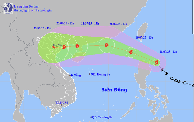
A map shows the projected locations and path of storm Wipha as of 1:00 pm on July 18, 2025. Photo: Vietnam’s National Center for Hydro-Meteorological Forecasting
Mai Van Khiem, director of the National Center for Hydro-Meteorological Forecasting, issued the warning during a storm response meeting organized by the Ministry of Agriculture and Environment on Friday afternoon.
At midday on Friday, Wipha intensified to level 8-9 (62-88 kph) on the Beaufort scale, with gusts up to level 11 (103-117 kph), moving west-northwest at around 20 kph.
Satellite imagery showed convective clouds consolidating around the storm's center, signaling further intensification.
Khiem said that Wipha will possibly enter the East Vietnam Sea by early Saturday and officially become the third storm to hit the maritime area this year.
Favorable environmental conditions, including high sea surface temperatures, strong oceanic heat content, low wind shear, and favorable upper-level divergence, are projected to support the storm’s continued intensification over the next two to three days.

Mai Van Khiem, director of Vietnam’s National Center for Hydro-Meteorological Forecasting. Photo: Chi Tue / Tuoi Tre
However, the storm's path remains uncertain.
Forecast models differ by more than 100 kilometers on Wipha’s potential track as it approaches the eastern waters off China’s Leizhou Peninsula.
If the storm veers north or south, its impacts on Vietnam’s mainland could vary significantly.
Regarding intensity, international models also diverge.
Some predict Wipha may reach level 12 (118-133 kph) with gusts up to level 15 (167-183 kph) while near the eastern coast of China’s Hainan Island, weakening slightly to around level 10 (89-102 kph) as it enters the Gulf of Tonkin and approaches Vietnam.
Wipha is expected to enter the Gulf of Tonkin on Monday morning, with potential land impacts beginning later that night.
From July 21 to 24, northern and central Vietnam could face heavy to extremely heavy rainfall.
If the storm tracks further north along China’s Guangxi coast, the impacts may lessen.
“Because Wipha has not yet entered the East Vietnam Sea, current projections are preliminary and subject to change. The public should closely monitor updated forecasts,” Khiem stressed.
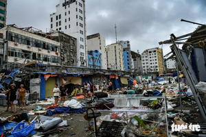
About typhoon Yagi, it made landfall in northern Vietnam in early September last year, killing more than 290 people and damaging 237,000 homes.
It is the most powerful storm to have entered the East Vietnam Sea over the past 30 years and the worst typhoon to have hit Vietnam in the last 70 years.
Key points to watch for storm Wipha
- Conditions remain highly favorable for intensification.
- The storm is projected to enter the East Vietnam Sea early on Saturday, with its peak intensity near the east of China’s Leizhou Peninsula.
- Its rapid movement is expected after entering the East Vietnam Sea, potentially affecting the Vietnamese mainland between Quang Ninh and Nghe An starting July 21-22.
- Heavy rainfall is anticipated in northern and north-central Vietnamese provinces from July 21 to 24.
- Wipha’s early trajectory resembles typhoon Yagi, prompting strong storm preparedness, especially for winds reaching levels 10-11 (89-117 kph) and gusts up to 14-15 (150-183 kph).


Max: 1500 characters
There are no comments yet. Be the first to comment.