
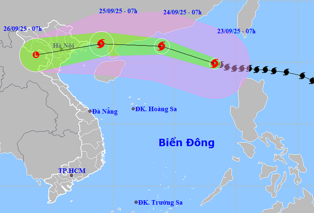
A map shows the projected locations and path of super typhoon Ragasa, as recorded at 7:00 am on September 23, 2025. Photo: Vietnam’s National Center for Hydro-Meteorological Forecasting
The National Center for Hydro-Meteorological Forecasting reported that Ragasa maintained winds at level 17 (202-221 kph), gusting above level 17, when it entered the northeastern part of the East Vietnam Sea at 7:00 am on Tuesday.
The storm, the ninth to hit the East Vietnam Sea this year, was tracking west-northwest at 20 kph and is expected to sustain its super typhoon strength through Tuesday.
Addressing a meeting in response to the storm late on Monday, Mai Van Khiem, head of the national weather center, warned that as Ragasa moves toward Guangdong Province in southern China, it will gradually weaken before crossing China’s Leizhou Peninsula and entering the Gulf of Tonkin on Thursday.
Upon its landfall along the coastal areas from Quang Ninh to Thanh Hoa, winds may reach levels 9-11 (75-117 kph), gusting up to level 14 (150-166 kph).
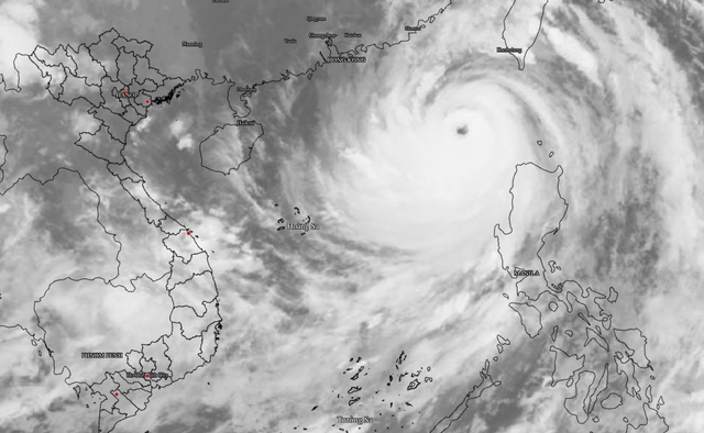
Satellite image of super typhoon Ragasa at 5:00 am on September 23, 2025. Photo: Vietnam's National Center for Hydro-Meteorological Forecasting
Khiem said satellite analysis shows Ragasa’s convective cloud tops reaching minus 70 to minus 80 degrees Celsius, with a warm, cloud-free eye above 15 degrees Celsius, which indicates an extremely intense storm system.
From Wednesday, strong winds of level 8-13 (62-149 kph) are forecast over the Gulf of Tonkin, with waves up to seven meters offshore and 2-4 meters along the coastal areas from Quang Ninh to Thanh Hoa.
The strongest winds are expected on land during Thursday.

Mai Van Khiem, head of Vietnam’s National Center for Hydro-Meteorological Forecasting, briefs attendees on super typhoon Ragasa’s potential impact on the country at a meeting hosted by the Ministry of Agriculture and Environment on September 22, 2025. Photo: C. Tue / Tuoi Tre
Heavy rainfall is also expected. The northern and north-central provinces from Thanh Hoa to Ha Tinh may see 70-150 millimeters of rain.
Meanwhile, Thai Nguyen, Tuyen Quang, Lao Cai, Phu Tho, and the Red River Delta could experience 150-250 millimeters, with local totals exceeding 450 millimeters between Wednesday and Friday.
He cautioned that rainfall forecasts may shift as Ragasa moves closer to Vietnam, urging residents to monitor updated advisories.


Max: 1500 characters
There are no comments yet. Be the first to comment.