


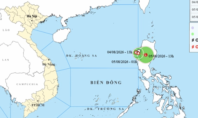
A map shows the projected position and track of a newly-formed tropical depression in the East Vietnam Sea, as recorded at 1:00 pm on August 4, 2026. Photo: Vietnam’s National Center for Hydro-Meteorological Forecasting
At 1:00 pm on Tuesday, the tropical depression’s maximum sustained winds near the center reached 39-49 kph, with gusts up to 62-74 kph.
The national weather agency said the system is moving slowly eastward with little change in intensity.
By 1:00 am on Wednesday, the tropical depression’s center is expected to be over the southeastern waters of the northern East Vietnam Sea, maintaining its strength.
Later that morning, it may travel east-southeast at about 10 kph, making landfall in the Philippines’ Luzon Island before weakening into a low-pressure area.
Under the influence of the system, the southeastern waters of the northern East Vietnam Sea will experience winds of 39-49 kph, gusting to 62-74 kph, with waves 2-3 meters high and rough seas.
Vessels operating in these waters face risks from thunderstorms, whirlwinds, strong winds, and large waves.
Due to associated low-pressure troughs, northern and north-central Vietnam will possibly see moderate to heavy rain from late Tuesday through Wednesday, with total rainfall of 70-140 mm and localized areas exceeding 200 mm.
Rain is forecast to continue until Thursday, with some places receiving over 100 mm.
Overall rainfall from Tuesday to Thursday is expected to reach 100-200 mm, with localized totals above 300 mm.
Residents are warned of flash floods in small rivers and streams, landslides in mountainous areas, and urban flooding in low-lying zones.








Max: 1500 characters
There are no comments yet. Be the first to comment.