
A map shows the projected locations and path of a tropical depression in the Gulf of Tonkin as of 7:00 am on August 18, 2025. Photo: Vietnam’s National Center for Hydro-Meteorological Forecasting
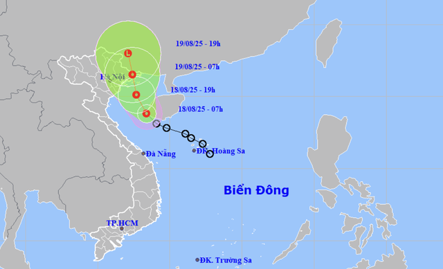
At 10:00 am on Monday, the tropical depression’s center was about 115 kilometers southeast of Bach Long Vi Island, a special zone administered by northern Hai Phong City, packing sustained winds at level 6-7 (39-61 kph) on the Beaufort scale, gusting at level 9 (75-88 kph).
The system is forecast to move northwest at around 15 kph over the next three hours.
The depression is predicted to make landfall in Quang Ninh Province, northern Vietnam early on Tuesday morning before weakening into a low-pressure system over the Vietnam-China border.
At 7:00 am on Tuesday, it is likely to be over Quang Ninh and Lang Son Province with winds at level 6 (39-49 kph), gusting at level 8 (62-74 kph).
The system is generating dangerous conditions at sea, including thunderstorms, waves of 2-3.5 meters, and strong winds in the Gulf of Tonkin and areas near Bach Long Vi and Co To Islands.
From Monday afternoon, coastal provinces and cities including Quang Ninh and Hai Phong are forecast to see level-6 winds and level-8 gusts.
Heavy rainfall is also expected.
From now through Wednesday morning, northeastern provinces and the north-central province of Thanh Hoa may receive 50-150mm of rain, with some areas exceeding 300mm.
During Monday, other north-central provinces like Nghe An and Ha Tinh could experience thunderstorms and receive precipitation of 20-60mm, with localized rainfall surpassing 120mm.
The national weather agency warned vessels operating in the affected areas of risks from thunderstorms, squalls, high winds, and rough seas.

Max: 1500 characters
There are no comments yet. Be the first to comment.