
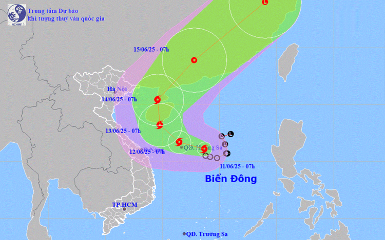
A map shows the projected path of storm Wutip in the East Vietnam Sea. Photo: National Center for Hydro-Meteorological Forecasting
This marked not only the first storm in the East Vietnam Sea for 2025, but also the first to form in the northwestern Pacific region this year.
The storm developed over the eastern area of Vietnam’s Hoang Sa (Paracel) archipelago.
Wutip is currently moving slowly west northwest at 5–10 kilometers per hour.
Satellite imagery showed a large storm cloud system leaning westward, already bringing rainfall across Vietnam’s Central Highlands, central, and south-central regions.
Moderate to heavy rains were recorded in some localities last night and early this morning.
The storm is forecast to maintain a northwesterly trajectory throughout today and tonight, heading toward Hainan Island in China, with increasing strength.
By 7:00 am on Thursday, Wutip is projected to be centered over Hoang Sa, reaching wind speeds of 75–88 km/h (level 9) with gusts up to level 11.
By Friday morning, the storm’s eye is expected to lie over the southern waters near Hainan Island, with sustained winds reaching level 10 (89–102 km/h) and gusts up to level 13.
This may be the storm’s peak intensity before it begins to weaken, as it moves inland over the Leizhou Peninsula and southern China.
Due to the storm’s impact, the northern East Vietnam Sea, including the Hoang Sa waters, and the northern part of the central East Vietnam Sea are experiencing thunderstorms and strong winds ranging from level 6 to 7.
Areas near the storm’s center may see winds of level 8–9, with gusts up to level 11, and sea waves between three and five meters high.
In the southern and central East Vietnam Sea, including Vietnam's Truong Sa (Spratly) archipelago, strong winds of level 6–7, with gusts up to level 9, are expected, causing rough seas and waves between two and four meters high.
All vessels operating in these dangerous zones are at risk from thunderstorms, strong winds, and high waves.
Downpours forecast across Vietnam
The national weather center warned that the storm might trigger a significant rain event across central Vietnam.
On Wednesday, the south-central, Central Highlands, and southern regions are expected to see moderate to heavy rains, with rainfall reaching up to 150mm in some areas.
From Wednesday night to Friday, the localities in central Vietnam from Quang Binh to Quang Ngai are forecast to receive 100–300mm of rainfall.
Northern parts of the Central Highlands may experience downpours with precipitation of up to 200mm.
Rainfall could exceed 200mm within six hours in some areas, raising the risk of flash floods and landslides.

Max: 1500 characters
There are no comments yet. Be the first to comment.