
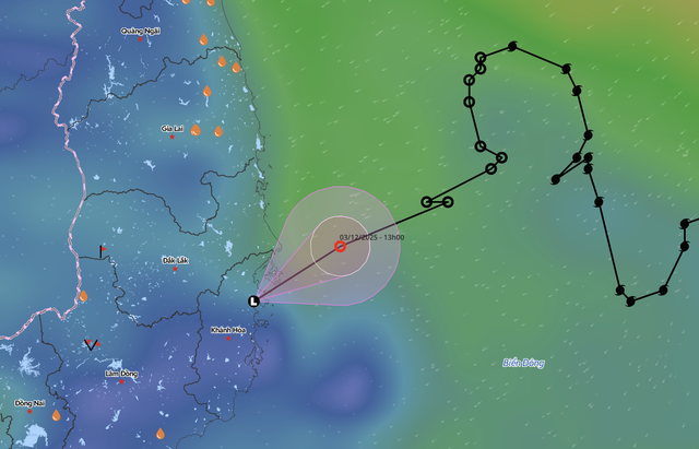
The position of the low-pressure area from storm Koto, the 15th storm to hit the East Vietnam Sea in 2025, as recorded at 7:00 pm on December 3, 2025. Photo: Vietnam Disasters Monitoring System
The National Center for Hydro-Meteorological Forecasting reported that at 7:00 pm on Wednesday, the center of the low-pressure system was located over the coastal areas from Dak Lak to Khanh Hoa, with maximum winds dropping below 39 kph.
Over the next 12 hours, the low-pressure area is forecast to move west-southwest at about 15-20 kph, pushing deeper inland before gradually dissipating.
The ongoing weather pattern is being driven by a combination of strengthened cold air, residual circulation from the weakened tropical system, and upper-level disturbances embedded in the easterly wind zone.
As a result, widespread rainfall is expected across central and south-central Vietnam.
On Thursday, the areas from southern Quang Tri to Da Nang and the eastern parts of Quang Ngai are forecast to receive moderate to heavy rain, with rainfall totals ranging from 70mm to 150mm. Some locations could see extreme rainfall exceeding 250mm.
The eastern areas of Gia Lai, Dak Lak, and Khanh Hoa are expected to record 40-90mm of rain, with isolated totals above 150mm.
Heavy rain is forecast to gradually decrease from Thursday night.
To proactively respond to flood, landslide, and flash flood risks, the National Civil Defense Steering Committee has issued an urgent directive to ministries and local administrations from Quang Tri to Da Nang.
Authorities have been ordered to inspect riverbanks, low-lying residential areas, and landslide-prone zones and to prepare for evacuations where necessary.
Safety checks are also required for small reservoirs, construction sites, mining areas, and vulnerable infrastructure.

Max: 1500 characters
There are no comments yet. Be the first to comment.