
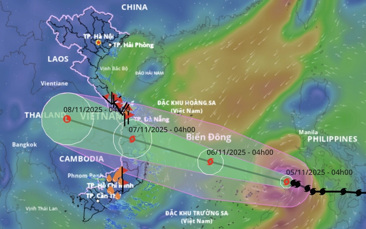
A map shows the projected path of storm Kalmaegi, as recorded at 7:00 am on November 5, 2025. Photo: Vietnam’s National Center for Hydro-Meteorological Forecasting
At 9:00 am Tuesday, the storm — the 13th to enter the region this year — was centered over the eastern part of the central East Vietnam Sea, about 470 kilometers east of Song Tu Tay Island.
Maximum sustained winds near the eye reached 134–149 kph, with gusts up to 201 kph.
Over the next 24 hours, Kalmaegi is forecast to move west-northwest at 20–25 kph and continue intensifying.
By 4:00 am on Wednesday, its center is expected to be near the northern Truong Sa (Spratly) Special Zone, about 550 kilometers east-southeast of Gia Lai Province’s coast.
It will likely move toward the central and south-central coast, potentially affecting the areas from Da Nang to Khanh Hoa late on Wednesday night.
Due to the storm’s effects, strong winds of 70–130 kph and waves 5–10 meters high have been recorded across the central East Vietnam Sea since Wednesday morning.
The coastal waters from Da Nang to Khanh Hoa, including Ly Son Island, have experienced winds of up to 149 kph, gusting to 201 kph, and nearshore waves of 6–8 meters.
Storm surges of 0.3–0.6 meters are expected along the coast from Hue to Dak Lak starting Wednesday evening, which may cause flooding in low-lying areas, overflow sea dikes and roads, and disrupt drainage.
Onshore winds will intensify across the coastal provinces from southern Quang Tri to Da Nang, eastern Quang Ngai, and Dak Lak, reaching 90–150 kph in some areas, while the western parts of Quang Ngai and Gia Lai may see gusts of up to 100 kph.
Heavy rain of 200–400 mm, with local totals exceeding 600 mm, is forecast from Da Nang to Dak Lak between Thursday and Friday.
Areas from southern Quang Tri to Hue, Khanh Hoa, and Lam Dong may receive 150–300 mm, with some spots surpassing 450 mm.
Rain will gradually ease from Saturday, while northern Quang Tri to Thanh Hoa may get 50–150 mm between Friday and Saturday.
Kalmaegi’s wide circulation could trigger thunderstorms, tornadoes, and strong gusts before and during landfall.
The National Civil Defense Steering Committee has directed the provinces from Ha Tinh to Lam Dong to secure residents, vessels, and property, especially in tourist areas, aquaculture zones, and offshore facilities.
Localities have been instructed to ban fishing and transport vessels, prepare evacuation plans for vulnerable areas, and ensure adequate shelter and supplies.
Provinces must also complete tree trimming, reinforce homes, protect key infrastructure and power systems, and suspend classes in high-risk areas.
Traffic restrictions will be implemented during the storm.
Reservoirs and construction sites are being inspected for safety, with operators in Quang Ngai to Dak Lak ordered to release water ahead of expected floods.
Urban areas have been told to clear drainage systems and help residents protect property to minimize storm and flood damage.

Max: 1500 characters
There are no comments yet. Be the first to comment.