
Thermal drones are extremely important for forest fire prevention efforts, providing strong support for firefighting and monitoring forces in Ca Mau Province, southern Vietnam. Photo: Thanh Huyen / Tuoi Tre
According to the provincial forest fire prevention and control steering committee, around 11,700 hectares is currently under Level III fire warning (high risk), 11,600 hectares under Level IV (dangerous), and more than 27,100 hectares under Level V, the highest and most dangerous fire warning level.
To improve monitoring capacity, U Minh Ha National Park has operated a specialized camera system for several years, described as 'smart eyes' in the middle of the melaleuca forest.
The system is installed on 26-meter observation towers in protected and administrative zones.
Its cameras can rotate 360 degrees with thermal imaging and optical lenses and operate continuously around the clock.
With a monitoring range of about five kilometers, each camera can monitor roughly 2,500 hectares of forest.
The 4K-resolution system allows images to be enlarged in 30-40 times, helping detect smoke or fire hotspots at an early stage.
When unusual signs are detected, the system automatically sends alerts and data to the control center and on-duty personnel through smartphones, enabling authorities to quickly verify the situation and deploy firefighting forces.
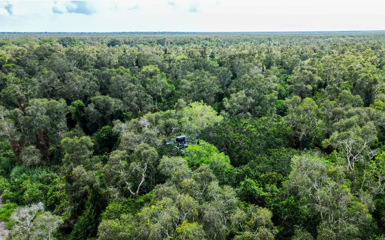
In addition to the camera network, thermal drones are also being used to support firefighting operations.

The surveillance camera cluster is regarded as a set of 'smart eyes' protecting the forest during the dry season, especially in the early rainy season when thunderstorms and lightning are frequent. Photo: Thanh Huyen / Tuoi Tre
Le Thanh Dung, deputy director of U Minh Ha National Park, said the park has been equipped with a thermal drone that has proven highly effective during the dry season.
He explained that during the early rainy season, thunderstorms and lightning make it unsafe for personnel to remain on steel observation towers, making drones particularly useful for detecting fires.
According to Dung, once a fire is discovered, drones can fly directly to the affected area, determine coordinates, and send data to response teams.
The system also helps determine the shortest route to the fire site, reducing emergency response time.
The park currently operates one camera cluster and has proposed investing in three additional clusters at a total cost of around VND7.2 billion (US$273,190).
Once completed, the expanded system is expected to cover nearly the entire forest area under the park’s management.
Dung also warned that unseasonal rains may cause some residents to become less cautious when entering forests to collect honey, while lightning strikes continue to increase the risk of fires.
Early rains can also wash away the acidic coating on melaleuca leaves and forest vegetation, potentially allowing fires to spread faster than usual.

Max: 1500 characters
There are no comments yet. Be the first to comment.