
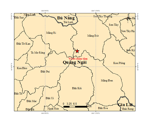
A map shows the epicenter of the magnitude-2.9 quake at 4:57 am on March 9, 2026 in Mang But Commune, Quang Ngai Province, central Vietnam. Photo: Vietnam’s Institute of Earth Sciences
The tremor occurred at 11:35 am with a focal depth of about 8.1 kilometers, said Nguyen Xuan Anh, director of the institute.
Authorities assessed the quake as posing no natural disaster risk.
The institute’s Earthquake Information and Tsunami Warning Center is continuing to monitor seismic activity in the area.
Earlier the same day, at 4:57 am, another earthquake of magnitude-2.9 was recorded in Mang But Commune.
On Sunday, three additional tremors ranging from 2.8 to 3.0 on the Richter scale also occurred in the same area.
All of the quakes were classified as minor and did not cause damage.
Anh said that the region, formerly part of Kon Tum Province, was once considered geologically stable, with only about 30 quakes recorded between 1903 and 2020, the strongest at magnitude-3.9.
However, since April 2021, hundreds of 'induced earthquakes' have been reported, particularly in the former Kon Plong area.
The largest recent events include a magnitude-5.0 quake on July 28, 2024, and a magnitude-4.9 tremor on October 6, 2025.
These quakes are linked to water accumulation in hydropower reservoirs, which increases stress along fault lines and triggers earlier-than-natural seismic activity.
Induced earthquakes often occur in cycles, with periods of frequent tremors followed by quiet phases, depending on reservoir operations.
Anh said future quakes in the area are expected to continue but are unlikely to exceed magnitude-5.5.
In Vietnam, quakes between 3.0 and 3.9 on the Richter scale are considered weak.
People may feel shaking or see household objects move, but damage is rare.

Max: 1500 characters
There are no comments yet. Be the first to comment.