
Flood-scarred Vietnam community builds digital map for better response
Driven by hard lessons from last year’s historic inundation, a central Vietnam locality not far from the famed Nha Trang beach has launched a digital map marking 90 critical locations to enable faster evacuation and rescue operations during future floods.
Local authorities in Tay Nha Trang Ward, located in Khanh Hoa Province, said the digital map marks 51 evacuation points, 24 high-risk flood zones, and 15 rescue stations — making it the province's first ward to adopt such an emergency tool.
The ward was among the hardest-hit areas in Khanh Hoa during last November's historic inundation.
The interactive tool aims to help residents, particularly those in low-lying neighborhoods, locate safe havens quickly while enabling emergency forces to coordinate rescue efforts more effectively.
Color-coded markers, QR code access
Residents can access the map by scanning a QR code with their phone cameras or through the Zalo app, which directs them to Google Maps, according to ward chairman Nguyen Dinh Anh Minh.
The locations are marked in different colors: green indicates safe evacuation points, red highlights dangerous areas such as places prone to deep flooding or landslides, and blue marks locations where rescue forces are stationed, Minh said.
By clicking on individual markers, users can view location names, addresses and phone numbers of officials or rescue personnel in charge.
The map also provides navigation directions to help residents reach designated locations.
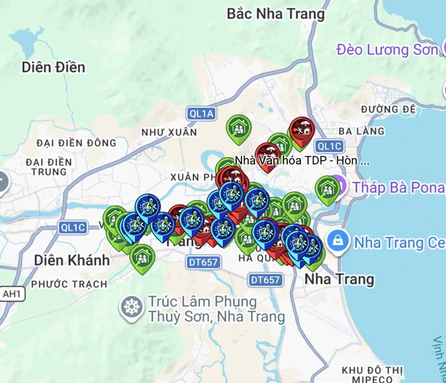
This screenshot shows a digital map indicating evacuation points, flood-prone areas and locations where rescue teams are stationed in Tay Nha Trang Ward, Khanh Hoa Province, south-central Vietnam.
Residents are advised to save information about evacuation points, rescue locations and relevant contact numbers on their phones so they can refer to it if internet or mobile network services are disrupted.
Minh said the ward's military command and relevant agencies had been assigned to regularly update information on evacuation points, dangerous areas and rescue teams on standby, while neighborhood groups were responsible for guiding residents in using the map.
The ward has also established emergency response teams in each neighborhood and mobilized donations to purchase life jackets and rescue boats for them, strengthening its ability to respond to floods under the four-on-the-spot principle, he added.
Historic floods highlight need for better preparedness
Tay Nha Trang was among the province's hardest-hit areas during the historic floods from November 16 to November 22, 2025, amid prolonged downpours.
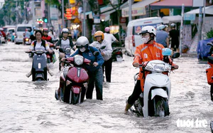
The disaster inundated around 80 percent of the ward's area, with floodwaters exceeding two meters in some locations, severely disrupting transportation, production and residents' daily lives, the local Khanh Hoa newspaper reported.
By November 19, rescue forces had evacuated more than 300 households, comprising nearly 600 people, to safety in the ward, the newspaper reported.
Across Khanh Hoa Province, the floods killed 22 people and injured 20 others, while more than 1,000 houses collapsed or were damaged and over 16,300 hectares of rice fields, other crops and fruit trees were affected, among other losses.
Infrastructure damage across the province totaled more than VND4.83 trillion (US$188 million), according to provincial figures.
The experience prompted the ward to strengthen its disaster preparedness, with the digital map expected to help reduce casualties and property losses during future floods.
Detention basin project aims to ease flooding
Alongside improvements in emergency response, Khanh Hoa authorities are pursuing longer-term infrastructure solutions to reduce flooding in Tay Nha Trang Ward.
The provincial administration has approved the feasibility study report for a stormwater detention basin project in the ward, with total investment of more than VND584.7 billion ($22.7 million) from the provincial budget, Khanh Hoa newspaper reported.
Scheduled for 2025-27, the project is expected to improve urban drainage, reduce flood risks during the rainy season and create more green public spaces.
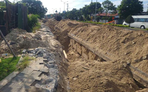
Covering approximately 13.78 hectares, the project includes a 10.28-hectare detention basin, a 1.51-hectare water inlet channel and a 1.24-hectare drainage channel leading to the Cai River.
The system will collect water from areas along the railway, channel it into the basin for temporary storage and flow regulation, and then discharge it into the river to ease pressure on the urban drainage network during heavy rainfall.
The project will also feature walking paths, green spaces, scenic rest areas, a three-span arched pedestrian bridge, lighting, parking areas, an operations building and public restrooms.
The detention basin is targeted for completion in 2027.

Vinh Tho - Nguyen Hoang / Tuoi Tre News
Link nội dung: https://news.tuoitre.vn/flood-scarred-vietnam-community-builds-digital-map-for-better-response-103261104215141998.htm