Storm Wipha enters East Vietnam Sea, forecast to intensify rapidly
Storm Wipha became the third storm to hit the East Vietnam Sea this year after entering the maritime area early on Saturday, according to the country’s National Center for Hydro-Meteorological Forecasting.
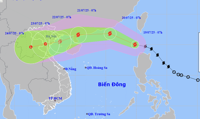
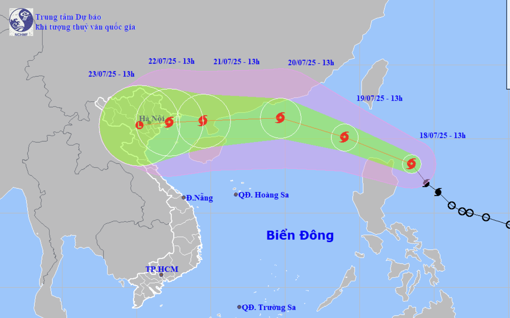
A map shows the projected locations and path of storm Wipha, the third storm to hit the East Vietnam Sea in 2025, as of 7:00 am on July 19, 2025. Photo: Vietnam’s National Center for Hydro-Meteorological Forecasting
As of 7:00 am on Saturday, Wipha's center was located in the northeastern part of the northern East Vietnam Sea with sustained winds of level 9 (75-88 kph) on the Beaufort scale and gusts up to level 12 (118-133 kph).
Nguyen Van Huong, head of the weather forecasting department at the National Center for Hydro-Meteorological Forecasting, said Wipha is moving in highly favorable conditions, including sea surface temperatures of 30-31 degrees Celsius and low vertical wind shear, which are factors that contribute to the storm’s rapid intensification over the next two days.
Wipha is expected to reach its peak intensity at level 12 (118-133 kph), with gusts up to level 15 (167-183 kph), as it nears the eastern coast of Leizhou Peninsula in China.
In the next 24 hours, Wipha is projected to move west-northwest at around 20 kph, increasing in strength.
By 7:00 am on Sunday, it will be approximately 600 km east of Leizhou Peninsula, with sustained winds of level 10-11 (89-117kph) and gusts up to level 13 (134-149).
From Sunday to Monday next week, the storm could maintain its westward direction and reach the eastern coast of Leizhou Peninsula by Monday morning, with wind speeds reaching level 11-12 (103-133 kph), gusting to level 14 (150-166 kph).
Between 48 and 72 hours from now, Wipha will possibly travel west-southwest at 20 kph, entering the Gulf of Tonkin.
By 7:00 am on Tuesday next week, it is forecast to be centered over the gulf with winds at level 9 (75-88 kph) and gusts to level 11 (103-117 kph).
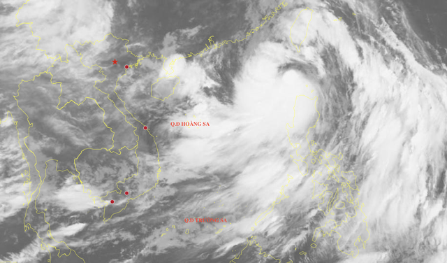
A satellite image reveals the cloud structure of storm Wipha at 7:00 am on July 19, 2025. Photo: Vietnam’s National Center for Hydro-Meteorological Forecasting
Over the following two to five days, Wipha will move primarily west-southwest at 10-15 kph, making landfall in northern Vietnam and gradually weakening.
Due to the storm's influence, eastern areas of the northern East Vietnam Sea will experience increasingly strong winds at level 6-7 (39-61 kph), strengthening to level 10-11 (89-117 kph) near the center, with gusts reaching level 13 (134-149 kph).
Wave heights are expected to range from four to six meters.
Vessels in these areas may be affected by thunderstorms, strong winds, and rough seas.
Speaking at a storm response meeting held on Friday afternoon, Mai Van Khiem, director of the national weather center, emphasized that Wipha's projected trajectory and behavior bear resemblance to devastating typhoon Yagi, which struck northern Vietnam last year.
Khiem urged the public and authorities to prepare for severe weather, monitor updated forecasts, and implement appropriate response measures.
Typhoon Yagi made landfall in northern Vietnam in early September last year, killing more than 290 people and damaging 237,000 homes.
It is the most powerful storm to have entered the East Vietnam Sea over the past 30 years and the worst typhoon to have hit Vietnam in the last 70 years.
Minh Duy - Chi Tue / Tuoi Tre News
Link nội dung: https://news.tuoitre.vn/storm-wipha-enters-east-vietnam-sea-forecast-to-intensify-rapidly-103250719100124988.htm