Super typhoon Ragasa expected to enter East Vietnam Sea tonight
Super typhoon Ragasa is forecast to enter the East Vietnam Sea on Monday night, becoming the ninth storm to strike the maritime area this year. It could reach the Gulf of Tonkin by early Thursday before making landfall between Quang Ninh and Ha Tinh Provinces, said the national weather agency.
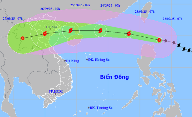
A map shows the projected locations and path of super typhoon Ragasa, as recorded at 7:00 am on September 22, 2025. Photo: Vietnam’s National Center for Hydro-Meteorological Forecasting
According to the National Center for Hydro-Meteorological Forecasting, at 7:00 am on Monday, Ragasa’s center was about 160 kilometers northeast of Luzon Island in the Philippines, packing sustained winds at level 17 (202-220 kph) and gusts beyond level 17.
Ragasa is expected to intensify further as it tracks west-northwest at 20 kph.
By Tuesday morning, the typhoon will be over the northeastern East Vietnam Sea with peak intensity at level 17, sustaining super typhoon status.
On Wednesday, it is forecast to approach 370 km east of China’s Leizhou Peninsula, with strength at levels 16-17 (184-220 kph).
Ragasa is predicted to weaken slightly as it crosses southern China before entering the Gulf of Tonkin early on Thursday at levels 13-14 (134-166 kph), then striking northern Vietnam later the same day.
The national weather center warned of a worst-case scenario if Ragasa maintains a lower track westward, retaining higher intensity when entering the Gulf of Tonkin.
This would increase the impact of destructive winds and waves along Vietnam’s northern and north-central coasts from Quang Ninh to Hue.
Besides, an early-season cold air mass is also moving south, which could interact with the typhoon and alter its track and intensity.
The agency added that forecasts beyond three days remain highly uncertain.
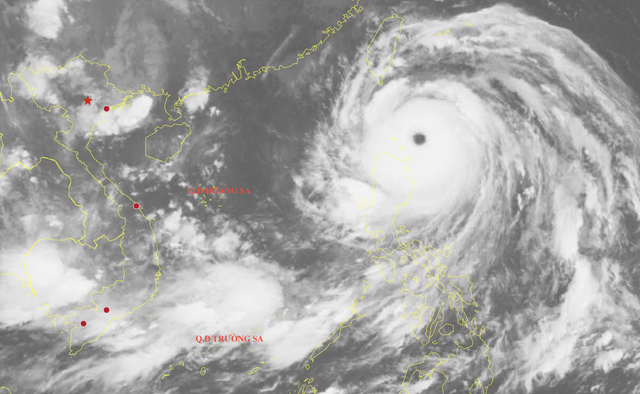
Satellite image of super typhoon Ragasa at 7:30 am on September 22, 2025. Photo: Vietnam’s National Center for Hydro-Meteorological Forecasting
From Monday, the northern East Vietnam Sea, including Vietnam’s Hoang Sa (Paracel) Special Zone, will possibly see winds at levels 8-9 (62-88 kph), later rising to 10-14 (89-166 kph), with areas near the storm center reaching levels 15-17 (167-220 kph).
Waves could top 10 meters, creating extremely dangerous conditions for all vessels, including large cargo ships.
By Wednesday, the Gulf of Tonkin, including Con Co, Bach Long Vi, and Co To Islands, may experience winds at levels 11-13 (103-149 kph) with gusts up to level 16 (184-201 kph), violent seas, thunderstorms, and heavy rains.
By early Thursday, the coastal areas from Quang Ninh to Ha Tinh are expected to endure winds at levels 9-10 (75-102 kph), with areas near the eye at levels 12-14 (118-166 kph), gusting to level 16, and waves up to seven meters.
The center urged coastal provinces to prepare for severe impacts, warning that fishing fleets, aquaculture farms, and beach tourism sites from Quang Ninh to Da Nang could all be at high risk.
It also noted that Ragasa’s intensity could be equivalent to the peak strength of typhoon Yagi, the third storm to hit Vietnam in 2024 and the most powerful to strike the East Vietnam Sea in the past three decades.
Typhoon Yagi claimed the lives of hundreds of people in early September last year.
Minh Duy - Chi Tue / Tuoi Tre News
Link nội dung: https://news.tuoitre.vn/super-typhoon-ragasa-expected-to-enter-east-vietnam-sea-tonight-103250922100554399.htm