
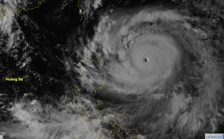
Satellite image of storm Ragasa at 1:50 pm on September 21, 2025. Photo: National Center for Hydro-Meteorological Forecasting
Its center was located about 430 km east of Luzon Island in the Philippines.
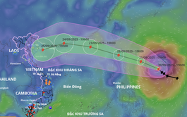
The latest forecast from the meteorological agency indicates that within the next 24 hours, Ragasa will strengthen into a super typhoon with intensity reaching level 16–17.
After that, Ragasa is expected to maintain its strength at level 16–17 as it enters the East Vietnam Sea.
This would make it the strongest storm in the maritime region since the start of the 2025 storm season.
As the storm nears the waters off Guangdong Province in China, it is expected to gradually lose strength, veer toward the Leizhou Peninsula, and then move into the Gulf of Tonkin.
The storm may directly affect the northern provinces of Vietnam around September 25–26.
Over the next 24 hours, Ragasa is forecast to move in a west-northwest direction at a speed of 15–20 km/h.
By 1:00 pm on Monday, the storm is expected to be located about 120 km north of Luzon Island, with maximum intensity at level 16–17 and gusts exceeding level 17.
During the following 24 to 48 hours, Ragasa will continue moving west-northwest at 15–20 km/h, entering the East Vietnam Sea.
It is likely to become the ninth storm to hit the sea this year .
By 1:00 pm on September 23, the storm's center will be over the eastern waters of the northern part of the East Vietnam Sea, maintaining winds at level 16-17 and gusts above level 17.
In the following 48 to 72 hours, the storm will continue moving west-northwest at 20–25 km/h, with intensity forecast to gradually decrease.
By 1:00 pm on September 24, the storm’s center will be over the waters near Guangdong Province, with winds decreasing to level 15 (167–183 km/h) and gusts still above level 17.
Between 72 and 96 hours from now, the storm will shift direction to west-southwest, traveling at approximately 20 km/h, crossing the Leizhou Peninsula and entering the Gulf of Tonkin, with continued weakening.
By 1:00 pm on September 25, the storm’s center will be located over the eastern waters of the northern Gulf of Tonkin, with winds at level 14 (150–166 km/h) and gusts reaching level 17.
Thereafter, the storm is forecast to continue moving west-southwest toward the northern and north-central provinces of Vietnam.
Starting from Monday, the eastern part of the northern East Vietnam Sea will experience increasing wind speeds, initially at level 8–9, rising to level 10–14, and level 15–17 with gusts above level 17 in areas near the storm's center.
Sea waves may exceed 10 meters in height, and the sea will be extremely rough.
All vessels operating in these dangerous zones may be affected by thunderstorms, whirlwinds, strong winds, and high waves.
The meteorological agency has issued a level-four disaster risk warning about the eastern waters of the northern East Vietnam Sea.
The National Center for Hydro-Meteorological Forecasting also predicted that between September 21 and October 20, two to three more storms or tropical depressions may form in the East Vietnam Sea, with one to two possibly affecting Vietnam’s mainland.
Cold air may begin to appear by late September, but it is expected to be weak and unstable, thus not significantly altering temperatures in northern provinces.
Widespread rains are likely to occur in the northern region and Thanh Hoa Province in the north-central region.
From Nghe An Province in north-central Vietnam to northern Khanh Hoa Province in south-central Vietnam, widespread heavy rains are also likely.
Other regions may experience several days of showers and thunderstorms, with some days seeing moderate to heavy rainfall.
Across the country, hazardous weather phenomena such as thunderstorms, tornadoes, lightning, hail, and strong gusty winds may continue.

Max: 1500 characters
There are no comments yet. Be the first to comment.