
Tropical depression forms in Gulf of Tonkin, southern Vietnam braces for evening showers
A tropical depression developed over the Gulf of Tonkin on Friday morning, while southern Vietnam is forecast to experience showers and thunderstorms later in the day, according to the National Center for Hydro-Meteorological Forecasting.
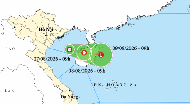
A map shows a tropical depression’s projected position and track in the Gulf of Tonkin at 9:00 am on August 7, 2026. Photo: Vietnam’s National Center for Hydro-Meteorological Forecasting
At 9:00 am, the tropical depression’s center was located over waters southeast of Bach Long Vi Special Zone in northern Vietnam’s Hai Phong City, with maximum sustained winds of 39-49 kph and gusts of 62-74 kph.
The system is predicted to move east-southeast at about 5 kph and may reach northeastern Hainan Island in China, before weakening into a low-pressure area over the East Vietnam Sea.
Due to the influence of the system, strong winds of 39-49 kph, gusting to 62-74 kph, and waves of 2-3 meters are expected in the Gulf of Tonkin, creating rough seas.
Similar wind conditions are forecast for parts of the East Vietnam Sea, including Vietnam’s Hoang Sa (Paracel) and Truong Sa (Spratly) Special Zones, and the waters from Gia Lai Province to Lam Dong Province throughout Friday.
Thunderstorms, whirlwinds, and large waves pose risks to vessels operating in these waters.
The national weather agency forecasts that northern Vietnam and north-central provinces from Thanh Hoa to Quang Tri will see scattered showers and thunderstorms on Friday, with rainfall of 15-30 mm and localized totals above 80 mm.
By evening, the Central Highlands and southern Vietnam are expected to receive 15-30 mm of rain, with some areas exceeding 60 mm, along with scattered thunderstorms.
Heavy downpours may trigger flash floods in small rivers and streams, landslides on slopes, and flooding in low-lying areas.
Strong winds, lightning, and hail could damage crops, trees, houses, and infrastructure.
- REFERENCE MORE
Minh Duy - Chi Tue / Tuoi Tre News
Link nội dung: https://news.tuoitre.vn/tropical-depression-forms-in-gulf-of-tonkin-southern-vietnam-braces-for-evening-showers-103260807114147411.htm