Vietnam’s Da Nang to Lam Dong face flood, landslide risks as storm Koto may bring heavy rainfall
Storm Koto is expected to bring moderate to heavy rain to south-central Vietnam as it moves across the East Vietnam Sea, prompting warnings of high risks of flooding, landslides, and flash floods from Da Nang City to Lam Dong Province.

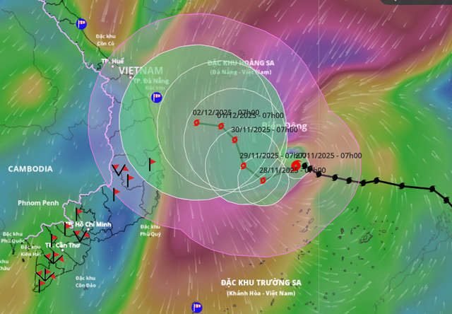
A satellite image shows the position and forecast track of storm Koto, as recorded at 7:00 am on November 27, 2025. Photo: Vietnam Disasters Monitoring System
According to the National Center for Hydro-Meteorological Forecasting, the center of Koto was located about 180km north of Song Tu Tay Island at 7:00 am on Thursday.
The storm’s maximum sustained winds near its center reached 118-133 kph, with gusts of 167-183 kph.
Over the next 24 hours, the storm is forecast to move west-southwest at about 5-10 kph.
Meteorologists cautioned that both the track and intensity of storm Koto, the 15th to hit the East Vietnam Sea this year, may continue to change in the coming days.
Although the storm’s exact direction remains uncertain, its circulation combined with an advancing cold air mass is expected to cause widespread moderate to heavy rainfall from Da Nang to Lam Dong.
Given that many areas are still recovering from prolonged heavy rain in recent days, the risk of secondary disasters remains extremely high.
Authorities warned of a strong possibility of landslides, flash floods, and localized flooding in low-lying areas, particularly in mountainous and river basin regions that have already been saturated.
On Wednesday, Prime Minister Pham Minh Chinh signed an urgent directive to ministries and to local administrations from Da Nang to Lam Dong, ordering them to take proactive and maximum-level preventive measures well in advance.
PM Chinh instructed coastal cities and provinces to urgently guide vessels still operating at sea, especially in areas likely to be affected directly by the storm, to move away from danger or return to safe shelter.
Local authorities were also ordered to urgently review and finalize storm-response scenarios, including immediate evacuation plans for residents in high-risk zones such as aquaculture farms and areas prone to landslides, flash floods, and severe inundation.
The Ministry of Agriculture and Environment was tasked with providing the most accurate and timely forecasts, regularly updating dangerous zones so both authorities and residents can respond appropriately.
Meanwhile, the Ministry of National Defense and the Ministry of Public Security were told to prepare forces and equipment to assist with evacuations and emergency rescue operations when needed.
Other relevant ministries were ordered to ensure safety for transport systems, power grids, telecommunications, schools, hospitals, tourist facilities, and production zones.
Cold air strengthens, southern Vietnam turns cooler

Ho Chi Minh City and other southern provinces are expected to experience cooler temperatures over the next two days as cold air moves southward. Photo: Le Phan / Tuoi Tre
As the strong cold air mass pushed deeper southward on Thursday, Ho Chi Minh City experienced notably cooler and drier conditions.
Early in the morning, temperatures dropped to around 21 degrees Celsius, creating a fresh, mild atmosphere that residents described as unusually pleasant for the city.
According to the Southern Regional Hydro-Meteorological Station, strengthened continental cold high pressure is spreading further south, placing southern Vietnam under a stronger northeast monsoon.
Daytime temperatures across the region are expected to fall by two degrees Celsius.
Night-time temperatures in the eastern parts of the south are forecast to range from 19 to 22 degrees Celsius, with some places below 19 degrees.
In the country’s Mekong Delta, temperatures are expected between 21 and 24 degrees Celsius.
Over the next few days, storm Koto is forecast to continue pressing against the cold air mass, helping drive cool air straight down the mainland.
Southern Vietnam is expected to see clear skies at night, sunny days, and chilly early mornings.
On Friday morning, minimum temperatures in the southeastern part may drop to 19-21 degrees Celsius, with some locations below 18 degrees.
Minh Duy - Chi Tue - Le Phan / Tuoi Tre News

