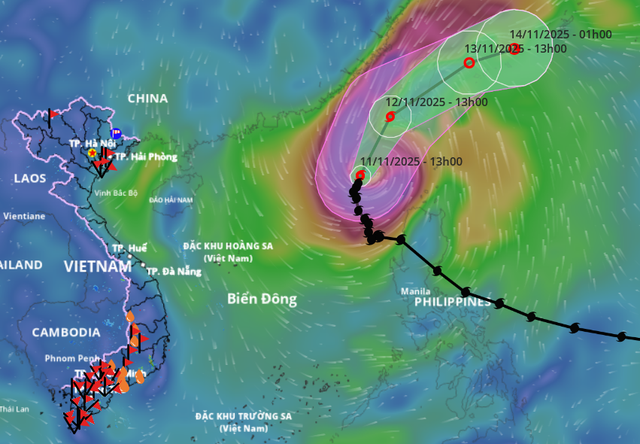
A satellite image shows the position and forecast track of storm Fung Wong, as recorded at 1:00 pm on November 11, 2025. Photo: Vietnam Disasters Monitoring System
Fung Wong, the 14th to enter the East Vietnam Sea this year, packed maximum sustained winds near the center at 103-117 kph, with gusts up to 150-166 kph.
Over the next 24 hours, it is forecast to move north-northeast at about 15 kph.
By 1:00 pm on Wednesday, the storm’s center will be over the northeastern part of the northern East Vietnam Sea, maintaining winds of 89-102 kph and gusts of 134-149 kph.
Between 24 and 48 hours, Fung Wong is expected to continue northeastward at 20 kph, making landfall in Taiwan and weakening into a tropical depression by Thursday, before further degrading into a low-pressure area as it moves east-northeast.
The national weather agency described the storm’s track as unusual for the late season.
Typically, storms at this time of year move west or west-southwest toward Vietnam’s south-central coast.
However, Fung Wong is veering northward and then out to sea.
This pattern results from a weakened and southward-expanded subtropical ridge north of the storm, altering the steering currents and causing the storm to drift north.
As it climbs to higher latitudes, the system enters the upper-level westerly flow, which will steer it east-northeast and out of the East Vietnam Sea.
As a result, storm Fung Wong is unlikely to affect Vietnam’s mainland.
Due to the storm’s influence, the eastern waters of the northern East Vietnam Sea are experiencing winds of 50-74 kph, with the area near the center reaching 75-117 kph and gusts up to 150-166 kph.
Wave heights are estimated at 4-6 meters, rising to 7-9 meters near the storm’s eye.
All vessels operating in these dangerous waters are warned of severe thunderstorms, strong winds, and large waves.


Max: 1500 characters
There are no comments yet. Be the first to comment.