

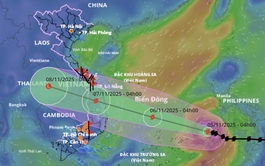
A satellite image shows the projected path of storm Kalmaegi, as recorded at 1:00 pm on November 5, 2025. Photo: Vietnam Disasters Monitoring System
As of 12:00 pm on Wednesday, Kalmaegi’s eye was located about 360 kilometers east of Song Tu Tay Island in Vietnam’s Truong Sa (Spratly) Special Zone, with sustained winds of 134-166 kph and gusts up to 202 kph, according to the National Center for Hydro-Meteorological Forecasting
The storm was moving west-northwest at 25 kph, heading toward the waters off Da Nang City to Khanh Hoa Province, and could strengthen further before making landfall.
The national weather agency noted Kalmaegi may maintain that intensity as it approaches the coast and could cause winds of 89-133 kph, gusting up to 150-183 kph in Quang Ngai, Gia Lai, and Dak Lak upon its landfall.

The agency has issued a level-4 disaster risk alert for the central East Vietnam Sea, including the northern Truong Sa area, as well as coastal and inland zones from Quang Ngai to Dak Lak.
Surrounding areas from the southern part of Quang Tri Province to Da Nang are under a level-3 alert.
Kalmaegi’s projected path and impact are similar to storm Damrey, which struck former Phu Yen Province and Khanh Hoa in 2017, and storm Molave, which hit former Quang Nam Province and Quang Ngai in 2020.
In the central East Vietnam Sea, winds near the storm’s center are forecast to rise to 118-166 kph, gusting up to 202-220 kph, with waves up to 10 meters high.
By Thursday, coastal areas from Da Nang to Khanh Hoa, including the Ly Son Special Zone, could face similar conditions, and waves 6-8 meters high.
From Thursday evening, storm surges of 0.3-0.6 meters combined with high tides may cause coastal flooding and seawall damage across low-lying areas from Hue City to Dak Lak.
The coastal areas from Quang Tri to Da Nang, and the eastern parts of Quang Ngai to Dak Lak, will experience winds of 39-61 kph, gusting up to 183 kph, with the strongest winds expected from late Thursday to early Friday.
Quang Ngai and Gia Lai will see winds up to 74 kph, gusting to 102 kph, possibly damaging infrastructure and housing.
Heavy rainfall of 200-400 mm, locally over 600 mm, is forecast from Thursday to Friday in Da Nang to Dak Lak, while southern Quang Tri, Hue, Khanh Hoa, and Lam Dong could receive 150-300 mm, locally over 450 mm.
Rain will spread northward to Quang Tri-Thanh Hoa on Friday and Saturday, with 50-150 mm expected, locally over 200 mm.
Authorities warn of flooding, flash floods, and landslides in low-lying and mountainous regions from Ha Tinh to Khanh Hoa, especially in areas recently saturated by earlier storms.

Max: 1500 characters
There are no comments yet. Be the first to comment.