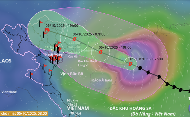
A forecast map shows the position and projected path of storm Matmo as of 7:00 am on October 5, 2025. Photo: Vietnam Natural Disaster Monitoring System
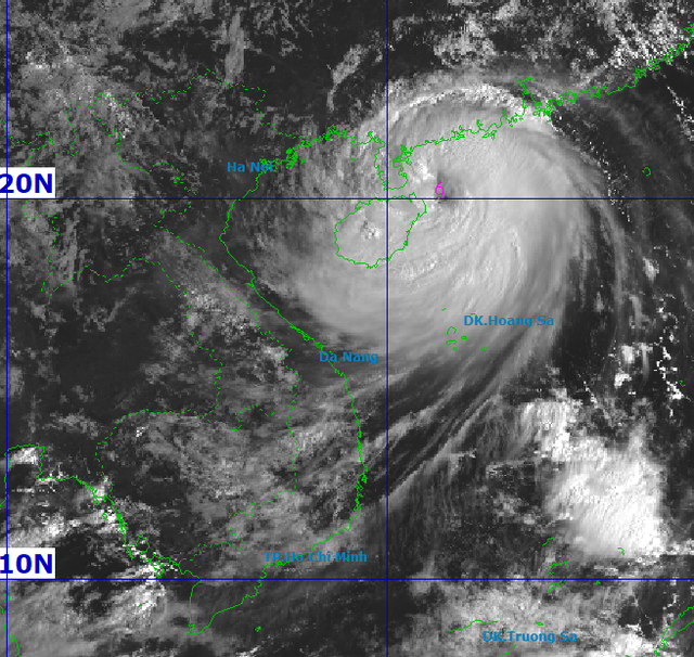
As of 5:00 am on Sunday, the storm’s center was located about 150 kilometers east of China’s Hainan Island and approximately 550 kilometers east-southeast of Vietnam’s Quang Ninh Province, with maximum sustained winds of up to 133 kph and gusts reaching 183 kph.
Matmo is expected to continue moving west-northwest at a speed of 20–25 kph, crossing China’s Leizhou Peninsula on Sunday afternoon before entering the Gulf of Tonkin.
By 7:00 pm, its center is forecast to be in the eastern part of the gulf, around 190 kilometers east-southeast of Quang Ninh, with slightly weakened winds of 120–134 kph and gusts of 167–183 kph.
The storm is expected to make landfall in the border region between Quang Ninh and Guangxi early on Monday morning, before weakening into a tropical depression and later a low-pressure system over northern Vietnam’s mountainous areas.
Due to Matmo’s influence, the northwestern part of the northern East Vietnam Sea is experiencing strong winds of up to 102 kph, increasing to 149 kph near the storm’s center, with gusts reaching 167–201 kph.
Waves are 4–6 meters high, rising to 6–8 meters near the storm’s center, creating very rough seas.
From late Sunday afternoon, the northern Gulf of Tonkin — including Bach Long Vi, Van Don, Co To, Cat Hai, and Hon Dau Islands — will experience rough seas with winds strengthening to 102 kph and waves 2–4 meters high.
Near the storm’s center, winds may reach 133 kph with gusts up to 183 kph, and waves 3–5 meters high, causing extremely rough seas.
The coastal areas and islands of Quang Ninh and Hai Phong are expected to see storm surges of 0.4–0.6 meters.
Flooding may occur in low-lying coastal and estuarine areas due to storm surges and large waves from Sunday afternoon.

A satellite image shows storm Matmo at 8:00 am on October 5, 2025. Photo: National Center for Hydro-Meteorological Forecasting
From Sunday night until Tuesday noon, the coastal areas from Quang Ninh to Hung Yen Provinces and Lang Son Province will experience strengthening winds of 39–102 kph, with gusts reaching 133 kph.
The inland areas of the northeastern region will have winds of 39–49 kph and squalls of up to 74 kph.
Heavy rain is forecast across northern Vietnam from Sunday night through Tuesday night.
Mountainous and midland regions could receive 150–250 mm of rainfall, with some areas exceeding 400 mm.
The Red River Delta and Thanh Hoa may see 70–150 mm, locally over 200 mm.
Hanoi is forecast to experience moderate to heavy rainfall of 70–120 mm, with some areas exceeding 150 mm from early Monday through Tuesday.
Forecasters have warned of possible flash floods, landslides, and urban inundation in low-lying areas, as well as thunderstorms, tornadoes, and strong gusts before and during the storm’s landfall.
At the same time, heavy rainfall exceeding 150 mm within three hours could cause severe flooding in low-lying and urban areas, along with flash floods and landslides in mountainous regions.


Max: 1500 characters
There are no comments yet. Be the first to comment.