
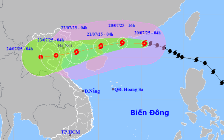
A map shows the projected locations and path of storm Wipha, the third storm to hit the East Vietnam Sea in 2025. Photo: Vietnam’s National Center for Hydro-Meteorological Forecasting
At 4:00 am on Sunday, the eye of the storm was spotted over the northern part of the East Vietnam Sea, about 830 km east of Quang Ninh Province and Hai Phong City, with maximum sustained winds reaching level 11 and gusts up to level 14.
In the next 24 hours, Wipha is likely to move westward at 20-25 km/h and continue to strengthen.
By 4:00 am on Monday, the center of the storm is forecast to be over northeastern China’s Leizhou Peninsula.
The storm is then predicted to shift west-southwestward into the Gulf of Tonkin on Monday.
By 4:00 am on Tuesday, its center will be over the coastal waters between Quang Ninh and Ninh Binh Provinces, with strong winds of level 10-11 (89-117 kph) and gusts up to level 14.
On Tuesday, Wipha will continue moving inland across the northern region of Vietnam at around 10 km/h, gradually weakening into a tropical depression and then a low-pressure system.
Due to the impact of the storm, the northern waters of the East Vietnam Sea are experiencing powerful winds ranging from level 8 to 10, and sea waves reaching up to seven meters.
The northern part of the Gulf of Tonkin will see increasing winds on Sunday night.
Southern Gulf of Tonkin waters will also be affected on Monday, with winds increasing to level 6-7 and gusts up to level 11.
Vessels in these zones are at risk from high waves, strong winds, thunderstorms, and tornadoes.
Strong winds, heavy rain hit northern provinces
The coastal provinces from Quang Ninh Province to Thanh Hoa Province are expected to experience powerful winds from the evening of Monday.
Winds will intensify to level 7-9 with gusts of level 10-11, especially in coastal areas.
Inland areas may see winds at level 6-7, with gusts reaching level 8-9.
Between Monday and Wednesday, the northern and north-central regions of Vietnam may suffer widespread heavy rain, with rainfall reaching up to 300 mm.
In particular, the northeast region, Thanh Hoa, and Nghe An are forecast to receive extremely heavy rainfall of 200-350 mm, and in some areas, precipitation may exceed 600 mm.

Max: 1500 characters
There are no comments yet. Be the first to comment.