


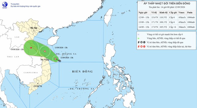
A map shows the projected position and track of a tropical depression in the East Vietnam Sea, as recorded at 1:00 pm on September 12, 2026. Photo: Vietnam’s National Center for Hydro-Meteorological Forecasting
At 1:00 pm on Saturday, the depression’s center was about 230 kilometers southeast of Da Nang, with maximum sustained winds of 39-49 kph and gusts up to 74 kph, according to the National Center for Hydro-Meteorological Forecasting.
Over the next 24 hours, the system is expected to move northwest at about 10 kph along the coastal waters from Da Nang toward Quang Tri, with little chance of strengthening.
By 1:00 pm on Sunday, the depression is projected to be 130 km east of Quang Tri and approximately 90 km northeast of Hue, maintaining its current strength.
From Sunday afternoon into Monday, the system is forecast to move west-northwest, potentially making landfall in Quang Tri before weakening into a low-pressure area.
The system, combined with the intertropical convergence zone and the northeast monsoon, has already brought heavy rainfall to provinces from Quang Tri to Quang Ngai.
The agency warned that rainfall will intensify and shift northward through next Wednesday.
On Sunday, southern Nghe An to Hue could receive rainfall of 80-180 mm, with localized totals above 300 mm. Thanh Hoa, northern Nghe An, Da Nang, and eastern Quang Ngai may see rainfall of 30-70 mm, with some areas exceeding 120 mm.
From Sunday night, rain is forecast to spread into the Red River Delta, with 20-40 mm expected and more than 60 mm in some locations.
By Monday, heavy rain will focus on the north-central and northern regions. Areas from Thanh Hoa to Quang Tri are forecast to receive 70-150 mm, with localized totals exceeding 250 mm.
The northern midland and Red River Delta areas, southern Son La and Phu Tho, and Tuyen Quang and Lao Cai Provinces are expected to receive 30-60 mm, with isolated areas recording more than 100 mm.
Heavy rain in these areas could persist through next Wednesday.
The downpours are also expected to trigger a flood wave on rivers from Thanh Hoa to Da Nang between Saturday and next Wednesday.
Low-lying areas along rivers and urban areas face a high risk of flooding, while landslides could occur on steep slopes in provinces and cities from Thanh Hoa to Da Nang.
The National Civil Defense Steering Committee has ordered coastal localities from Quang Ninh to Dak Lak to inform vessels of the tropical depression’s path, enforce sea bans where necessary, and prepare evacuations in flood-prone zones.
Mountainous areas are urged to relocate residents from landslide-prone slopes and riverbanks.
The steering committee also stressed the need to secure hydropower dams, reservoirs, and mining sites to prevent accidents during the tropical depression.









Max: 1500 characters
There are no comments yet. Be the first to comment.