
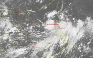
Satellite imagery shows the projected path of a tropical depression in the East Vietnam Sea at 7:00 am on September 6, 2025. Photo: Vietnam Disasters Monitoring System
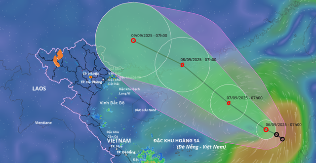
At 7:00 am on Saturday, the tropical depression’s center was located northeast of the East Vietnam Sea with maximum sustained winds of 50-61 kph, gusting to 75-88 kph.
It was traveling northwest at 10-15 kph and may strengthen into a storm within the next 24 hours.
By 7:00 am on Sunday, the system is expected to be about 430 kilometers northeast of Vietnam’s Hoang Sa (Paracel) Special Zone, with sustained winds of 62-74 kph, gusting to 89-102 kph.
The storm may intensify further as it continues northwest, reaching coastal Guangdong Province in China by Monday with sustained winds of 75-88 kph, gusting to 103-117 kph.
Over the following 48-72 hours, it is expected to keep moving northwest at around 15 kph.
Due to its impact, the northeastern part of the East Vietnam Sea is forecast to see winds of 39-74 kph, gusting to 89-102 kph, with waves 2-4 meters high and rough seas.
Vessels operating in the area may experience thunderstorms, squalls, strong winds, and large waves.
The Ministry of Agriculture and Environment has instructed the coastal provinces from Quang Ninh to Dak Lak to closely monitor the system, inform vessel operators about its position and movement, and ensure safety measures.
Local authorities are also required to prepare rescue resources and strictly prevent vessels and fish farms from remaining in dangerous zones.

Max: 1500 characters
There are no comments yet. Be the first to comment.