


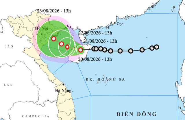
A map shows the projected position and track of a tropical depression, as recorded at 1:00 pm on August 20, 2026. Photo: Vietnam’s National Center for Hydro-Meteorological Forecasting
At 1:00 pm on Thursday, the tropical depression was centered over Hainan Island, packing winds of 39-49 kph with gusts reaching 62-74 kph, according to Vietnam's National Center for Hydro-Meteorological Forecasting.
The system is forecast to move slowly west-northwest at 5-10 kph over the next 24 hours before entering the Gulf of Tonkin, where it could strengthen into a storm.
By 1:00 pm on Friday, the storm is projected to reach the eastern Gulf of Tonkin with winds of 62-74 kph and gusts of 89-102 kph.
Over the following days, it will travel westward at 3-5 kph, passing near Bach Long Vi Island off Hai Phong City, northern Vietnam before approaching the waters of Quang Ninh, Hai Phong, and Hung Yen.
It could weaken later with winds of 39-61 kph and gusts of 75-88 kph.
By 1:00 pm on Sunday, the system is forecast to be over coastal areas stretching from Quang Ninh to Hung Yen.
The system is expected to bring hazardous marine conditions.
Strong winds of 39-49 kph with gusts of 62-74 kph and waves of 2-4 meters are expected in the northwestern East Vietnam Sea.
In the Gulf of Tonkin, winds will possibly strengthen to 39-61 kph, with gusts up to 88-102 kph and waves reaching 2.5-3.5 meters from Thursday evening.
Vessels operating in the affected areas could be exposed to thunderstorms, whirlwinds, and rough seas.
The national weather agency also warned of widespread heavy rain across northern and central Vietnam over the coming days.
From now until Friday, central Vietnamese provinces from Thanh Hoa to Quang Tri will see rainfall of 40-90 mm, with precipitation in some areas exceeding 180 mm.
On Thursday night, central localities from Quang Tri to Hue, the Central Highlands, and southern Vietnam will receive 20-40 mm of rain, with localized totals above 70 mm.
During Friday, northeastern provinces are expected to experience 40-100 mm of rain, with some areas surpassing 200 mm.
Rainfall may continue through Saturday and beyond, raising risks of flooding in low-lying areas, flash floods in small rivers, and landslides in mountainous terrain.








Max: 1500 characters
There are no comments yet. Be the first to comment.