
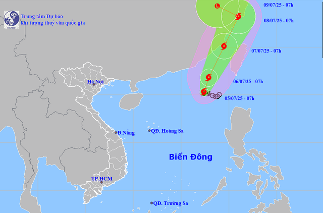
A map shows the projected locations and path of storm Danas in the East Vietnam Sea as of 7:00 am on July 5, 2025. Photo: Vietnam’s National Center for Hydro-Meteorological Forecasting
The National Center for Hydro-Meteorological Forecasting reported that Danas’ center was located in the northeastern East Vietnam Sea as of 7:00 am on Saturday, packing maximum sustained winds near the eye reaching level 8-9 (62-88kph) on the Beaufort scale, with gusts up to level 11 (103-117kph).
In the next 24 hours, the storm is expected to move slowly northward at 5-10kph, potentially gaining strength.
By 7:00 am on Sunday, it is forecast to remain over the northeastern East Vietnam Sea, intensifying to level 10-11 (89-117kph), with gusts up to level 13 (134-149kph).
Then, Danas may turn north-northeast at around 15kph, maintaining its strength.
By 7:00 am on Monday, the storm will likely be off the coast of China’s Fujian Province, packing winds of level 10 (89-102kph), gusting up to level 12 (118-133kph).
Over the next three days, Danas is expected to continue tracking northeast along the Taiwan Strait while gradually weakening.
By 7:00 am on Tuesday, it may make landfall in China’s Zhejiang Province, with wind speeds at around level 8 (62-74kph), gusting to level 12.
Subsequently, Danas is anticipated to travel north-northwest at approximately 10kph and gradually weaken further.

Current forecasts indicate that storm Danas will not impact mainland Vietnam.
However, due to its influence, the northeastern East Vietnam Sea is experiencing stormy weather, with wind speeds of level 9-11 (75-117kph) near the center, gusting up to level 13. Waves in the region may reach heights of four to six meters.
All vessels operating in affected waters are at risk of thunderstorms, squalls, strong winds, and high seas.

Max: 1500 characters
There are no comments yet. Be the first to comment.